Overview
Map

Introduction
Let’s discover together the enchanting "Malga Ra Stua" with this hike, whose destination is a splendid alpine refuge immersed in the greenery of its pastures.
It is an easy walk for everyone, but it needs a minimum of training both for the height gain of three hundred meters, one thousand feet, and for the duration of about two hour and a half. This walk is not suitable for small children and people with reduced mobility.

This hike can be found in Tabacco Map 003, "Cortina d'Ampezzo e Dolomiti Ampezzane," and goes along Path 6. Alternatively, you can see our route on Google Maps by clicking here.
We think that this hike is even better by following two different routes for the ascent and descent. We will go up along the main road, through the forest, and we'll descend along the aided path that follows the banks of "Boite" river, next to its splendid gorges and waterfalls.

Path of the hike
This hike starts in the parking area called "Sant'Uberto." If you are unsure of how to reach it, we will describe it in depth down on the page in the chapter "How to Get There." Alternatively, clicking the name will open the location on Google Maps.
The asphalt road to "Malga Ra Stua" is constantly traveled by cars, bicycles, and shuttles, which makes it not ideal for those who wish to get there walking. For this reason, we will take an alternative route.

When you get to the barrier, that blocks the passage of the cars, take the path to the left, it is marked by the wooden sign "Percorso pedonale per Malga Ra Stua", that means footpath to "Malga Ra Stua".

Continue along the path into the forest, being careful not to stumble on the roots and stones. The climb is moderately gentle, with a few little steeper traits.

When trail intersects the paved road, cross it, always checking for vehicles. Enter the path in the woods on the opposite side, keep following the wooden sign "Percorso pedonale per Malga Ra Stua"

Within a short time you will reach a scenic spot, where you could rest for a moment while enjoying the beautiful view of "Antruiles" valley and the Mount "Croda d'Antruiles".

From here, the road continues flat, crossing the asphalt road and then entering the woods again. All along the route, you will spot the red and white trail markers on the trees, confirming that you are following the right path.

One you reach the intersection marked by the sign "Ponte de Antruiles" Q. 1512, which means bridge of "Antruiles", take the right. The road will start to climb again. keep following the wooden sign "Percorso pedonale per Malga Ra Stua"

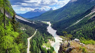
Keep walking until you reach the bridge on the "Boite" river. This stream, which here may seem negligible, is the same that crosses all the "Cadore" and gives the name to the "Boite" valley.

Once you cross the wooden bridge, the ascent will become steeper, even though it's pretty short. The road is less visible but always well-marked. If you keep following the most traveled route, it is virtually impossible to get in the wrong direction.

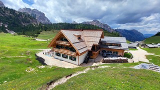
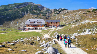
When the dirt road ends, leaving room for the asphalt road, you have basically arrived at your destination. Continue uphill for a few meters, until you reach "Malga Ra Stua." As mentioned previously, this mountain lodge is immersed in vast green pastures, where you can spend a few relaxing hours immersed in nature.

Near the mountain hut, you will likely see grazing animals. Cows are peaceful animals, but don't bother them. If you are afraid, just ignore them completely, otherwise they may think you have food and come to check.

As mentioned, we recommend going back through the equipped path of the "Boite" river waterfalls. Take the asphalt road that goes down towards Cortina, after a few meters you will see a small metal bridge and a wooden sign "Souto de Ra Stua" Q 1662. Follow the sign "Cascate del Boite", crossing the bridge.

This is a new path that allows you to admire the waterfalls from a new perspective. This path is not for everyone because there are iron ladders and, in some passages close to the river, it may be slippery because of the humidity. It is objectively easy, but we do not recommend it to small children or those who have mobility difficulties.

The equipped path runs along the riverbed for about twenty minutes, offering splendid views of the waterfalls. Once you reach the asphalt road take it, going down, towards the "Sant'Uberto" car park, like we did. You may also reconnect to the road in the woods that you took for the climb.

If you decide to take the road in the woods, after about five hundred meters of asphalt road, take the crossroads to the right. Unfortunately the paths have recently been modified and we have not yet had the opportunity to walk along them and photograph them. As soon as the snow melts we will update the page.
Curiosities
The name "Ra Stua" comes from the Ampezzo dialect, where "Stuà" means "to stop a watercourse". At this location, in the past, there was a temporary dam, which was used to transport the lumber down the "Boite" River. Some of those logs were cutted in the sawmills of the town, others continued their journey till "Piave" River, from which they were shipped to Venice.
"Ra Stua" is located inside the Ampezzo Dolomites Park and is a natural pasture for cows, horses and goats. In addition to the farmed species, the pasture is also frequented by some wild animals, typical of this area, such as marmots, roe deer and chamois. We took the photo below in the meadows nearby.

The newly managed farmhouse has about 40 seats inside and 60 outside. The menu consists of typical Ampezzo and traditional homemade dishes. In addition to the restaurant, the mountain lodge also offers bedrooms, with shared or private bathrooms. You can find more information on their official website.
"Malga Ra Stua" is the starting point of many hikes, so the road to the mountain lodge is quite busy. To avoid congestion, during the months of July and August, it is closed to traffic. During these periods it is possible to take a shuttle service, at an approximate cost of 10€ each in the locality of Fiames.
The "Boite" originates very close to the pastures of "Ra Stua", exactly in the locality of "Cianpo de Crósc". There is a beautiful hike, that crosses "Cianpo de Crósc", and takes you to "Fodara Vedla", another nice mountain lodge. It takes about an hour, if you still have some energy and want to lengthen your hike a bit, we have talked about it on the next page:
Another beautiful hike that starts from "Ra Stua" that we want to suggest you is the one that takes you to the "Rifugio Sennes", another mountain lodge of the area. We describe it below:
How to get there
The parking area of "Sant'Uberto", also known as "tornichè,", is a large gravel square where you can park your car for 8€ per day. In peak season, it is surely better to arrive early in the morning, otherwise it's likely that all the parking spaces will be occupied. From the center of Cortina, "Sant'Uberto" is approximately a twenty minute drive, following the signs to Dobbiaco.
If the parking lot is full, you may continue along the state highway in the direction of Dobbiaco, to try to park on one of the few lay-bys along the road, being very careful not to block the roadway, to avoid getting a ticket. Proceeding further you will find a roadman's house on the left, which is also the last reasonable spot where you might park, to not get too far.
If you want to get there with public transportation you can take the bus that goes to Dobbiaco. In order to reach the car park of "Sant'Uberto", You have to get off at the stop at the Roadmen's house at Podestagno. Behind the roadman's house there's a road in the woods that will take you to the parking area in about fifteen minutes. If you need more information on this road, we talked about it on the page on the walk to the ruins of the "Podestagno" castle:
Unfortunately there are only a few buses that can take you there, approximately one every two hours. In peak season there could be more, but for every information you should ask the Seam ticket office at the bus station. It may be closed during lunch hour.
Since the area is not well served by public transport, an excellent alternative to reach the parking lot to "Malga Ra Stua" is to take a taxi. The price should be around 35€, but it could vary a lot, both for the type of vehicle and the number of people, you should always ask for a quote. Taxis can be found both in Roma Square and at the bus station, or you can visit the Taxi official website.
If you need any information there is a tourist information office. It is located in the town center, near the church.
Useful information
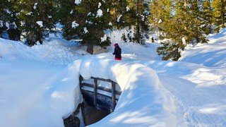
This hike is practicable only in summer, as the trail is not beaten in winter. With snow, it is possible to ascend along the main road, but we describe the winter hikes better in the next page:
Usually, the best months for this hike are between May and November. Unfortunately, it is not possible to know in advance how much it will snow and when the snow will melt.
If you decide to eat at the mountain lodge, the facility may be closed from mid-April to mid-May and from mid-October to mid-December. If you plan a visit in low season you should check on the website or by phone to see if they are actually open.
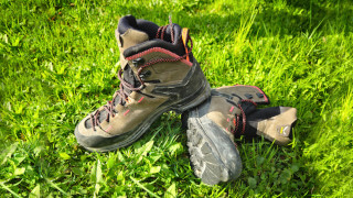
Even though this hike is considered simple, you should always use sturdy shoes and carry a backpack with some water, a snack and a jacket for the rain. If you want more information, we recommend you read our tips for first-time hikers:
We want to emphasize that, in the Dolomites, there are rules to be followed. The main ones are:
- It is strictly forbidden to light fires.
- It is strictly forbidden to pick plants and flowers.
- Free camping is prohibited.
- It is prohibited to abandon garbage.
- It is mandatory to keep pets on a leash.
Conclusion
We hope you liked this page on the hike from "Sant'Uberto" to "Malga Ra Stua". Before saying goodbye, we would like to mention that you can find other amazing hikes in Cortina and its surroundings by clicking here.
If you want to thank us you can read the page Support us. If you only want to suggest a change, propose something or just say hello, in the section contacts and info you'll find all the ways to reach us.