Overview
Map

Introduction
The hike that starts from "Malga Ra Stua" and gets to "Fodara Vedla" is an amazing hike through two nature parks to one of South Tyrol's most distinctive high-altitude mountain lodges.

This hike can be found on Tabacco Map 003, "Cortina d'Ampezzo e Dolomiti Ampezzane," and goes along Path 9. Alternatively, you can see our route on Google Maps by clicking here.
This is an easy walk in the sense that there are no cliffs or sections with climbing, but it is quite long and challenging. It is appropriate for a person with average training, but it's not recommended for young children or people with motor difficulties. The elevation gain is mainly concentrated on one climb.

Path of the hike
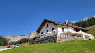
The hike to "Fodara Vedla" begins at the parking lot of "Malga Ra Stua," which can be reached on foot, by car, or by shuttle bus. If you are unsure of how to arrive here, we will describe it in depth down on the page in the chapter "How to Get There."

If you need to eat or drink something, you should stop at "Malga Ra Stua," since it's the only public place from there to "Fodara Vedla."

Take the gravel road that enters the pastures, along Path 6, follow the direction: "Rifugi, Val Salata e Ciampo de Croš."

The road continues for about fifteen minutes through meadows where it is possible to observe, in the summer months, some cows grazing peacefully.

These animals are used to the presence of people, but they should still be approached with respect, taking care not to annoy them. If a cow approaches you, it is probably just looking for food. If you do not want to be disturbed, just ignore her completely. Don't look at her, and she will lose interest in you.

The road ends at a large grassy pasture called "Ciampo de Croš." Here you'll find a crossroads and a hut, which you can see in the distance in front of you.

Take the road on the left, crossing the little bridge, and follow Path 9 towards "Rifugio Fodara Vedla" and "Lavinores." Get ready, because the only steep climb of the hike awaits you, where you will gain much of the four hundred meters, or one thousand feet, of positive elevation of the hike.

Now you have to face the climb, it's steep, but we assure you that you'll gain altitude fast, without making too much fatigue.

After about 30 minutes you'll reach a respectable altitude, as you'll be able to see from the panorama that will stand out below you.

From here, the road continues without major elevation changes, first through the forest and then opening up to a wide view of the Dolomite peaks.

Further on, the road gradually turns to the right, along the shores of a small lake known as "Rudo." It is an ephemeral lake, which is created in the spring as the snow melts and then disappears as soon as the water resources provided by the thaw run out.

Just before you reach the mountain lodge, without even noticing it, you will cross the border between the "Veneto" and "Trentino Alto Adige" regions. The border is marked by two wooden tables, one installed by the Ampezzo Dolomites Natural Park and the other by Fanes, Sennes, and Braies Natural Park.

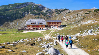
From here it is only a ten-minute walk to reach Fodara Vedla, which hides just behind the horizon, to the left of the trail that stands out in front of you.

Continuing on, if you look to your left, you should begin to see the mountain lodge, slightly lower than where you are walking. According to the signs, the walk should have taken you about an hour and a half.
At the mountain lodge, we ate the pressed cheese dumplings on a bed of cabbage; this plate is called "Canederli pressati al formaggio" in Italian, but here you will find most of the traditional South Tyrolean dishes.

If you don't want to stop at "Rifugio Fodara Vedla" or if there are too many people, you could always consider going back and eating at "Malga Ra Stua." The descent should take you about an hour; if you're not too hungry, it could be an excellent alternative.
Curiosities
"Fodara Vedla" was built as a World War I camp, but in 1923 it was taken over by Hans Mutschlechner and used as a cattle pasture. Following the arrival of tourism, the hut was converted into an accommodation facility, with rooms and a kitchen. To this day, the mountain lodge is still run by the Mutschlechner family, now in its fourth generation.
You will not find the classic symbols for men and women in the bathroom, but rather a much more distinctive system with chamois. The men's bath is identified with the male, recognizable by its horns and beard; the women's bath has the female chamois, without horns nor beard. As far as we know, the female chamois should also have horns, but we preferred to be discreet and not ask about the family situation of the portrayed specimens.

The name "Fodara" comes from the Ladin dialect and literally means sheep grazing. There are other similar examples, such as "Fedarola" at Cortina or "Fedares" in Val Badia.
If the hike has been too short you may want to go to the "Rifugio Sennes," that is a mountain lodge located about fifty minutes from here. Walk till the back of "Fodara" and take Path 7. After a few minutes, take the shortcut to the right, always along Path 7 and continue until you reach the "Rifugio Sennes." It is a slightly uphill walk, always well signposted.
If you want to have a better idea of the walk, by clicking here, you can see it on Google Maps, or you may prefer to click here to download the GPX route.
Once you reach "Sennes," you can easily return to "Ra Stua." If you need to know how, you can read our page, which you can find here:
How to get there
In order to get to "Malga Ra Stua" in the low season, the easiest way is to use the car. From the center of Cortina, you need to reach the "Sant'Uberto" parking area, also known as "tornichè." From here, you'll have to proceed along a rather steep and narrow road, towards the destination. There you will find the free parking lot of the "Malga."
"Ra Stua" is the starting point of many hikes. You should get there early in the morning to be sure to find a free spot. From the center of Cortina, you will need approximately a twenty five minutes drive.
The road towards "Malga Ra Stua" in July and August is closed to vehicles, but there is a shuttle service that costs approximately 10€ each. In this case, you have to park your car in the free parking area of Fiames to take the shuttle. It's better to get there early in the morning. You shouldn't take the presence of the shuttle for granted. Ask for information at the bus station; otherwise there is a tourist information office in the town center, whom you should ask.
There is no public transport directly to "Malga Ra Stua." In peak season, there are shuttle buses available, so you can take Bus No .1 at the Cortina bus station and get off at the stop of the Fiames Sport Center. You just need to cross the road to find the shuttles. You can buy the bus ticket at the ticket office at the bus station. Be careful, as the office may be closed during the lunch hour. The shuttle ticket can be taken directly to the starting point.
You could also take a taxi. From Cortina to the "Malga Ra Stua" the cost should be approximately €50. If the shuttle service is active, you may get off at Fiames. In this case the price will be lower, around 30€. Considering that prices could vary a lot, both for the type of vehicle and the number of people, you should always ask for a quote. Taxis can be found both in Roma Square and at the bus station, or you can visit the Taxi official website.
Even though this hike is already quite long, you might want to reach "Malga Ra Stua" on foot. In this case you may want to read our page on this hike, you can find it below:
If you need any information there is a tourist information office. It is located in the town center, near the church.
Useful information
The hike to "Fodara" should be done only in the summer. Although it never gets closed, bear in mind that the route is not beaten by snowmobiles or snowcats, so it's really hard to walk it safely in winter. The best months for this walk are from May to November, but unfortunately, every season is different, so we can't tell you in advance if you will find ice, mud, or a perfect road.
If you decide to eat or sleep in a mountain lodge, they are usually open for most of the year. If you don't want to have bad surprises, in low season, it is always better to call to check the actual opening.
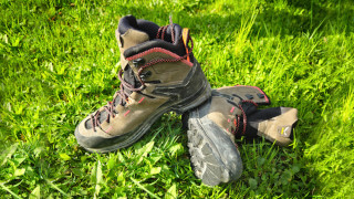
When you go hiking you should always use sturdy shoes and carry a backpack with some water, a snack and a jacket for the rain. If you want more information, we recommend you read our tips for first-time hikers:
We want to emphasize that, in the Dolomites, there are rules to be followed. The main ones are:
- It is strictly forbidden to light fires.
- It is strictly forbidden to pick plants and flowers.
- Free camping is prohibited.
- It is prohibited to abandon garbage.
- It is mandatory to keep pets on a leash.
Conclusion
We hope you liked this page on the hike from "Malga Ra Stua" to "Fodara Vedla." Before saying goodbye, we would like to mention that you can find other amazing hikes in Cortina and its surroundings by clicking here.
If you want to thank us you can read the page Support us. If you only want to suggest a change, propose something or just say hello, in the section contacts and info you'll find all the ways to reach us.