Overview
Map

Introduction
This hike to "Plätzwiese", in Italian "Prato Piazza", from "Cimabanche" takes place along the border between Cortina d'Ampezzo and the province of Bolzano, along the beautiful valley known as "Val dei Chenopi".

This hike can be found on Tabacco Map 010, "Dolomiti di Sesto," and goes through Path 18. Alternatively, you can see our route on Google Maps by clicking here.
This is a fairly demanding hike, both due to its length and the presence of a very steep climb, for this reason we recommend it only to trained hikers. It is not suitable for small children or people with reduced mobility.
A clarification about language. The vicinity of the South Tyrol makes it correct to name some locations both in Italian and German Austrian language. That's why we'll use both for some destinations, Italian first.
 Help us stay ad-free with a small offer.Donate now!
Path of the hike
This hike from "Cimabanche" to "Prato Piazza (Plätzwiese)" starts in this parking lot, in front of the roadman's house, at the top of "Cimabanche" Pass. It's easy to spot because of its red color. If you are unsure of how to reach it, we will describe it in depth down on the page in the chapter "How to Get There".

Once you are in the parking lot reach the metal bar and continue along the Path 18 in the direction of "Prato Piazza (Plätzwiese)", the path is also marked by a wooden sign.

During the first 30 minutes of walking you'll warm up your muscles, as the road goes smooth through the woods, without encountering strong steeps.

After walking through the woods for a bit, a slight climb awaits you, after there is a little river to cross and then you can continue gently climbing. The trees will begin to thin out, leaving the place to small patches of mountain pines.

These needle-shaped evergreen bushes are often found in Cortina. From the cones of these mountain pines is made the homonymous grappa, that we call "pino mugo", which you may have tasted in some restaurant or mountain lodges. One problem of the mountain pines is that they retain heat, if the day is warm, prepare yourself to sweat a little more than expected.
After about 20 minutes you'll find a wood sign that indicates "Prato Piazza 18" and, immediately after, there is a steep climb.

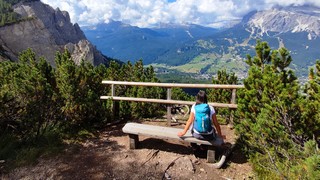
This part of the hike is pretty challenging, it is a climb of gravel and rocks, surrounded by mountain pines. Be careful where you put your feet, to avoid slipping. I assure you that the effort will be amply rewarded by the panorama that awaits you. So as not to ruin the surprise, we put a photograph that doesn't reveal too much.

Once you have passed this point you still need to make a little effort to reach the top. Consider that, once you have crossed the small wooden bridge, the worst is over. The climb becomes much easier and your destination is getting closer and closer.

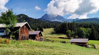
At this point you need to decide if you want to continue towards the original destination, walking other twenty minutes, or make a short detour to visit "Malga Stolla (Stolla Alm)", a very pretty cabin in the woods, which offers typical mountain dishes in an intimate and rustic setting. All you need to do is follow the directions.

If you prefer to avoid the detour, continue in the direction of "Prato Piazza (Plätzwiese)", walking for another twenty minutes, through the pastures, to reach the mountain lodge of the same name "Rifugio Prato Piazza (Plätzwiese hütte").
In our case "Malga Stolla" was closed, so we ate some excellent pressed dumplings on a bed of cabbage at the "Rifugio Prato Piazza (Plätzwiese hütte)".

On a full belly you can return to the car along the same road you took up, but there is also an alternative. If you are curious to know which one, continue reading.
Help us stay ad-free with a small offer.Donate now!
Curiosities
Considering that this hike is quite steep, you may want to go up to "Prato Piazza (Plätzwiese)" along a simpler road. There is an alternative that starts from the parking lot of Carbonin, and goes up along Path 37, an old military track. In this case the walk will be a little longer, but less steep. If you prefer a more detailed description, we suggest you click on the page below, where we talk about it in depth:
If you are curious to know the origin of the name of the path, it comes from the Ampezzo dialect, the word "chenòpo", means miner.
The area of "Prato Piazza (Plätzwiese)", is infamous because of its role during World War I. The forest road mentioned earlier, the one leading down to Carbonin, is actually an old military cartroad, along which it is possible to see the remains of a fort and abarracks, which were the first line against the Italian army.
In winter, the meadows of Prato Piazza are used to lay out a spectacular trail for cross-country skiing. If you are a lover of this sport you really should consider coming here to ski. The trail is quite easy, but the views are absolutely wonderful.
If you still have energy, there is a beautiful hike that starts from "Prato Piazza (Plätzwiese)" and climbs up to the summit of Mount Specie, from which you can see an unforgettable view of the Eastern Dolomites and the Three Peaks of Lavaredo. The walk will take you around three hours, with a positive difference in altitude of around 300 meters, 984 feet. The path is well signposted.
Help us stay ad-free with a small offer.Donate now!
How to get there
In order to reach "Cimabanche" it would be better to have a car. The best place to park the car is the parking lot in front of the roadman's house on the state road. The parking lot is free, so it's a good idea to get there early in the morning, to have more chances to find a free space. The parking lot is approximately a twenty minute drive from the center of Cortina.
If the parking lot is full, you can try to go back and park on one of the lay-bys along the road, but be very careful not to block the roadway, otherwise you might get a ticket.
If you want to use public transport, at the bus station of Cortina d'Ampezzo, you can take Bus No. 445 from Cortina to Dobbiaco and get off at the stop at "Cimabanche". Generally there's a bus every couple of hours, but in the peak season there may be more. Considering the seasonality, ve recommend asking the ticket office at the bus station more precise information or alternatives. It may be closed during lunch hour.
If you don't have a car you may also consider a Taxi. From Cortina to "Carbonin" the price should be, approximately, 50€, but it is better to ask the price beforehand, as this is a very rough estimate. You can find a Taxi both in Piazza Roma, at the bus station or using their website.
If you need any information there is a tourist information office. It is located in the town center, near the church.
Help us stay ad-free with a small offer.Donate now!
Useful information
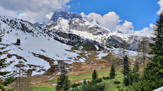
The hike from "Cimabanche" to "Prato Piazza (Plätzwiese)" should be done only in the summer season, because of some passages that, in the presence of snow and ice, could become quite dangerous. Usually the most suitable months for the hike are between June and October. This is a slightly conservative estimate, because every season is different. It is not possible to know exactly when it will snow and when the snow will melt. For example, we once did this hike in October and, in some places, there was already some snow.
If you decide to eat at one of the two mountain lodges it may be a good idea to call to verify the actual opening, because they may be closed in low season. In peak season, we recommend arriving for lunch a little earlier than usual to avoid the mess of the rush hours.
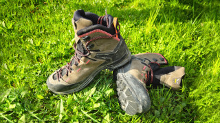
When facing a hike, we always recommend that you use appropriate clothing, starting with your shoes, which should be sturdy. Always carry a backpack with, at least, some water, a snack and a rain jacket. If you are new to hiking, we recommend you read the page we wrote on how to tackle a mountain outing:
We want to emphasize that, in the Dolomites, there are rules to be followed. The main ones are:
- It is strictly forbidden to light fires.
- It is strictly forbidden to pick plants and flowers.
- Free camping is prohibited.
- It is prohibited to abandon garbage.
- It is mandatory to keep pets on a leash.
Always be responsible and, when in doubt, stop. CiaoCortina cannot be considered responsible for any damage to things or people, variations, wrong path,, errors or inconveniences that may occur along the route. For more information, click here.
Help us stay ad-free with a small offer.Donate now!
Conclusion
We hope you liked this page about the hike from "Cimabanche" to "Prato Piazza (Plätzwiese)". Before saying goodbye, we would like to mention that you can find other amazing hikes in Cortina and its surroundings by clicking here.
If you want to thank us you can read the page Support us. If you only want to suggest a change, propose something or just say hello, in the section contacts and info you'll find all the ways to reach us.