Overview
Map

Introduction
The hike from "Malga Ra Stua" to the "Sennes Hütte" is a beautiful walk through two nature parks, with as its destination the most popular high-altitude mountain lodge in the entire Pustertal valley. In Italian, we call it "Rifugio Sennes," as the words "Hütte" and "Rifugio" both mean mountain lodge in Austrian German and Italian.

You can find this hike to the "Sennes Hütte" on the Tabacco Map 003 - "Cortina d'Ampezzo Dolomiti Ampezzane," along Path 6. Alternatively, you can see our route on Google Maps by clicking here.
This is a quite challenging hike, not difficult, but rather long. The difference in altitude is mainly concentrated in a single and steep climb. Although it can be done without too much difficulty by a person with average training, it is not recommended for small children and people with mobility difficulties.
 Help us stay ad-free with a small offer.Donate now!
Path of the Hike
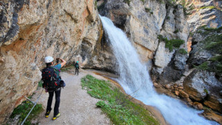
The hike to "Sennes Hütte," or "Rifugio Sennes," begins at the parking lot of "Malga Ra Stua," a restaurant with a bar, where you may drink a coffee or have breakfast before the walk.

We'd like to avoid writing here all the different ways to reach this mountain lodge; if you need detailed information, you can find it in the second part of this page, in the chapter "How to Get There."

From the parking lot of "Malga Ra Stua," you have to head toward the metal bar that blocks the passage of the cars and take Path 6, in the direction of "Rifugi, Val Salata e Ciampo de Crósc."

The road continues for about fifteen minutes slightly uphill through the pastures of "Ra Stua." This is a traditional place to graze cows, and it's likely you will see some grazing peacefully nearby.

These animals are used to the presence of people, so they can be approached without problems, but always with respect.
If you are afraid and a cow approaches, it's probably only looking for food. Just walk away, ignoring her completely, not even looking at her, and she will do the same to you.

Once you reach the wood sign that indicates "Ciampo de Crósc," continue straight, along Path 6, towards "Val Salata." From here the hike changes pace; the climb begins to become quite steep and will remain so for about forty minutes.

When the road surface, made of gravel, becomes concrete, you are approximately halfway up this steep climb towards the "Sennes Hütte" mountain lodge.

After a little, you will see a sign indicating "Senes scorciatoia." It means "shortcut to Senes." It's a decidedly steep road, which we recommend only using for the descent, but if you want to shorten the walk, it will save you about ten minutes.

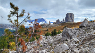
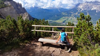
Once this part of the climb is finished, the slope will be much less pronounced, and you will be welcomed by some amazing panoramas.

The "Fanes, Sennes, and Braies" Natural Park will stand out in front of you, while behind you you will have a privileged view of the of the "Ampezzo" Dolomites Natural Park.

After about half an hour you will come across a crossroads that would allow you to reach the "Rifugio Biella" and Lake Fosses. Continue straight, always along Path 6; you are now only ten minutes from your destination.

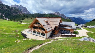
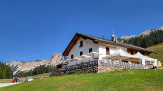
The "Sennes Hütte" will not appear in front of you, because it is hidden behind a small hill. Looking to the left, at a certain point, you will see an antenna appear, then the roof, and finally the entire structure.
According to many, this is the mountain lodge where you can eat the best in the entire "Pustertal," the name of this valley. We wanted to try the famous "schnitzel," a breaded cutlet, a dish of cabbage and eggs with speck. We've been very happy.

For the return we took the same road we used to get here, but we chose to go down the shortcut at the halfway point of the "Val Salata." We've done it mainly to create the GPX file, as it's steep enough to make it not recommended.
Help us stay ad-free with a small offer.Donate now!
Curiosities
In front of the "Sennes Hütte," you can see a long runway, which can make you wonder if it has been built for the landing of planes. As strange as it may seem, that is indeed its purpose. In 1968, during the Cold War period, Italy had deployed some military forces to guard its borders. To train pilots in mountain landings, the army built here a four hundred meter airfield, or one third of a mile. With the arrival of the helicopters, the runway fell into disuse.
We spent a lot of time trying to figure out whether the correct form was "Senes" or "Sennes." The natural park is almost always referred to as "Senes," but the official sources for the facility name it "Sennes Hütte." Both forms should be correct.
This area of the "Fanes, Senes and Braies" Natural Park is famous for being naturally frequented by chamois and ibex. Immediately after lunch we went out onto the terrace, and there was a friendly ibex grazing in front of the refuge, near the lake, to the delight of the hikers who watched him fascinated.

If you want to walk a little further, you could take the opportunity to visit another mountain lodge, "Fodara Vedla," which, from here, is about forty minutes away. It is an almost completely downhill hike, always well signposted. Take Path 7 in front of the "Sennes Hütte." After about twenty minutes, turn left, leaving the main road, and follow the shortcut in the woods, always along Path 7, until you reach "Fodara Vedla." If you want to get an idea of the route, by clicking here you can see it on Google Maps, or you may prefer to download the GPX route here. Once you reach "Fodara Vedla," you can go back to "Ra Stua" following another hike that we described on another page that you can read by clicking below:
 Help us stay ad-free with a small offer.Donate now!
How to Get There
In order to get to "Malga Ra Stua" in the low season, the easiest way is to use the car. In the months of June and July, the road from "Sant'Uberto" is closed to traffic. In this case, you have to leave the car in the locality of Fiames and take the shuttle. We'll describe it better a few lines below, in the public transport chapter.
If the road is open, from the center of Cortina, you need to reach the "Sant'Uberto" parking area, also known as "tornichè." From here, you'll have to proceed along a rather steep and narrow road towards the destination. There you will find the free parking lot of the "Malga," with a capacity close to fifty cars.
"Ra Stua" is the starting point of many hikes. You should get there early in the morning to be sure to find a free spot. From the center of Cortina, you will need approximately a twenty-five-minute drive.
Unfortunately, there is no public transport directly to "Malga Ra Stua." The bus n°1 can take you to the locality of Fiames, but from there, you'd have to walk for two hours, which is quite unreasonable. The solution is the private shuttle service, but it's only active in the peak season.
Let's suppose it's the peak season: June and July. The first step is to take bus n°1 from the Cortina bus station and get off at the stop of the Fiames Sport Center. For more information and to purchase tickets, you should contact the ticket office, which is located in the same office as the Tourist Information Center. It may be closed during lunch.
Once at the Sport Center, you just need to cross the road to reach the shuttles area. The tickets can be purchased directly onboard, and the price is approximately €10 each. Before assuming the availability of the shuttle service, always search for a confirmation; the easiest way is to contact the Dolomites of Ampezzo Park.
You could also take a taxi. From Cortina to the "Malga Ra Stua," the cost should be approximately €50. If the shuttle service is active, you may get off at Fiames. In this case the price will be lower, around €30. Considering that prices could vary a lot, both for the type of vehicle and the number of people, you should always ask for a quote. Taxis can be found both in Roma Square and at the bus station, or you can visit the taxi official website.
Even though this hike is already quite long, you might want to reach "Malga Ra Stua" on foot. This walk will take you about an hour and a half, and the length will be nearly three kilometers, or two miles.
If you choose to walk there, you should read our page about the walk from "Sant'Uberto" to the pastures of "Ra Stua." You can see it below:
If you need any information, there is a tourist information office. It is located in the town center, near the church.
Help us stay ad-free with a small offer.Donate now!
Useful information
The hike to "Rifugio Sennes," or "Sennes Hütte," can be done every month of the year, but in winter you will need snowshoes or mountaineering skis, as the snow on the track is not packed. You also need experience to walk or ski in fresh, packed, or frozen snow.
At certain times of the year, during the thaw, you may find ice in some places. To avoid slipping, it is best to be equipped with snow crampons to attach to your shoes. Unfortunately, every season is different, and it is not possible to know in advance when the snow will melt.
If you decide to eat at one of the mountain lodges described above, the facilities are usually open for most of the year. If you don't want to have bad surprises, in low season, it's always better to call to check the actual opening.
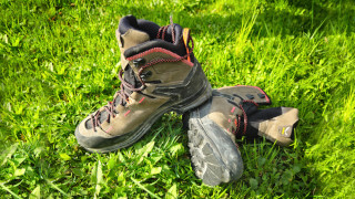
When you go hiking, you should always use sturdy shoes and carry a backpack with some water, a snack, and a jacket for the rain. If you want more information, we recommend you read our tips for first-time hikers:
We want to emphasize that, in the territory of the Dolomites, there are rules to be followed. The main ones are:
- It is strictly forbidden to light fires.
- It is strictly forbidden to pick plants and flowers.
- Free camping is prohibited.
- It is prohibited to abandon garbage.
- It is mandatory to keep pets on a leash.
Always be responsible, and when in doubt, stop. CiaoCortina cannot be held responsible for any damage to things or people, variations, wrong paths, errors, or inconveniences that may occur along the route. For more information, click here.
Help us stay ad-free with a small offer.Donate now!
Conclusion
We hope you liked this page on the hike from "Malga Ra Stua" to the "Rifugio Sennes." Before saying goodbye, we would like to mention that you can find other amazing hikes in Cortina and its surroundings by clicking here.
If you want to thank us, you can read the page Support Us. If you only want to suggest a change, propose something, or just say hello, in the section Contacts and Info, you'll find all the ways to reach us.