Overview
Map

Introduction
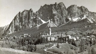
Let's discover together this walk to the "Podestagno" Castle, an ancient fortress that overlooked Cortina. Unfortunately, little more than the foundations remain of the castle, but from here, in addition to the ruins of the fortress, you will be able to observe a breathtaking view of the valley below. This place has two names, as it is normally referred to both as "Botestagno" and "Podestagno," which come respectively from its Italian and Austrian original names.

You can find this hike to the "Podestagno" Castle on the Tabacco Map 003 - "Cortina d'Ampezzo Dolomiti Ampezzane," along Path 201. Alternatively, you can see our route on Google Maps by clicking here.
It is a really simple and short walk that lasts for around forty minutes, so we'll also describe a deviation to see the locality of "Ospitale," where there are both the oldest little church in Cortina and one of the oldest inns in all of Italy.
 Help us stay ad-free with a small offer.Donate now!
Path of the Hike
This hike starts at the "Sant'Uberto" parking area, also known by many as "tornichè." If you are unsure of how to reach it, we will describe it in depth down on the page in the chapter "How to Get There." Alternatively, clicking on the name will open the location on Google Maps.

Once reached the parking area you have to find the path that will lead you to the roadman's house. The best thing to do, in order to avoid errors, is to walk back in the direction of the state road and take the intersection to the left, right at the end of the parking area, near the state road.
You have to take the dirt road blocked by a bar and signage to block vehicles passing. The path will probably be avoided by almost anyone else; it means it is the right direction. The picture below may help you.

Once you've crossed the bar, keep walking uphill for about ten minutes along the state road that heads towards "Dobbiaco (Toblach)," until you see a roadman's house, which is a red building, to be accurate, pompeian red.

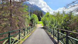
The roadman's house, in Italian "casa cantoniera," has this name because, in the past, it was used by the "cantonieri," who are the workers in charge of road maintenance. Now take the underpass, to cross the state road in complete safety.

After you've crossed the road you'll see a sign of the "Parco Naturale delle Dolomiti d'Ampezzo," that means "Natural park of the Ampezzo Dolomites." Here you can read some information about the place you are visiting.
From there you'll have to take the road to the right, as clearly indicated by the abundant signposting.

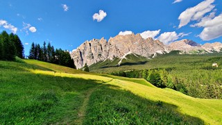
You will need only a few minutes to cross the meadow of the "Cason de Podestagno." It is the name of the small, private, wood chalet that you can see in the middle of the meadow.

From here, you will only need a very small effort to climb the last ascent that separates you from the ruins of the fortress.

The area of the "Podestagno" castle ruins has recently been enhanced by installing information boards about the history of the location, unearthing new remains and installing wooden railings for the safety of visitors.

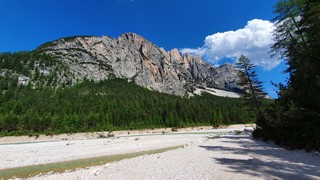
As mentioned earlier, from here, you can enjoy a splendid view of the entire "Ampezzo" valley. The reason why, in ancient times, it was decided to build an outpost at this location was that it allowed the soldiers to spot the arrival of enemy armies from a great distance.
Once you have completed your visit to the ruins of the "Podestagno" fortress, you could walk the same route back to your car, but considering how short and easy this walk has been, we recommend an alternative way to go back.
When you get to the sign of the Dolomites Natural Park, instead of turning left and crossing the underpass, continue along the gravel road in the direction of the locality of "Ospitale." By doing so, you will connect with the former railway road, and, in about two kilometers and a half, one and a half miles, you will reach the "Ristorante Rifugio Ospitale."
Here you can eat or drink something in one of the oldest inns in all of Italy; it's been in business since the 11th century. You may also visit the beautiful little church from 1226, the oldest in Cortina. The detour will take you about an hour, round trip.

This variant is not present on the map at the beginning of our article, nor on the GPX file of this hike. In any case, the road is perfectly signposted and it is practically impossible to take a wrong path. The only thing you need to pay attention to, on the way back, is to remember to turn towards "Podestagno" at the crossroads.
If you forget it, continuing straight along the former railway, you will reach the bridge over the stream "Rù Felizon", which you may have seen from the castle ruins. In this case just go back a few meters and take one of the roads to "Podestagno," always perfectly signposted.
Help us stay ad-free with a small offer.Donate now!
Curiosities
The more observant of you may have noticed that, sometimes, we named it the "Podestagno" Castle, others "Botestagno." This is not a typo: the name comes from "Boitestein," which means rock in the "Boite" Stream, but in ancient Austrian German it was known as "Peutelstein." Over time, the two definitions have probably been confused into two different names: "Podestagno" and "Botestagno." To date, both forms are correct, although we have always heard it called "Podestagno" Castle by practically everyone.
A thing that most ignores is that Gregorio Vecellio, father of the famous painter Titian, was the regent of the Fortress of "Podestagno" in the late 1400s. He was also superintendent of the castle of "Pieve di Cadore," as well as counselor and captain of the Militia for Venice. His was a very powerful family in "Cadore," and, at that time, "Ampezzo" was under its jurisdiction.

The underpass you crossed has not been built for the passage of people but to allow deer to pass under the state road, without risking being run over. These animals tend to follow the same paths, and here there's a high passage.
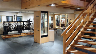
In the Ethnographic Museum of the Regole d'Ampezzo there is a scale reproduction of the fortress of Podestagno, before it was destroyed. If you want to see a photo of the model, or learn more about the museum, we suggest you read our page on the three museums of the "Regole" of Cortina:
The fortress of "Podestagno" was an ancient outpost that stood in defense of Cortina since the eighth century. It became crucial following the conquest of the territory by Venice and, later, by the Habsburg Empire. If you are interested in the past of Cortina and the fortress of Podestagno, you may read our article, you can read it below:
 Help us stay ad-free with a small offer.Donate now!
How to Get There
The "Sant'Uberto" parking area, also known as "tornichè," is the starting point of this walk. It is a gravel parking lot where it's possible to park for free in low season and with a €8 daily fee in the peak season. In the most crowded months you should get there as early in the morning as you can, to improve the chances of finding a free space. From the center of Cortina you'll need to drive approximately twenty minutes to get there, following the direction towards "Dobbiaco (Toblach)."
If you can't find a free place for your car, or you don't want to pay the parking, or you need to get as close as possible to the "Podestagno" Castle ruins you will need to proceed along the road in the direction of "Dobbiaco (Toblach)." You may try to park in one of the few lay-bys along the road, or you may proceed further until the roadman's house of "Podestagno" and park in the small parking area in front of the house.
Alternatively, you can also consider taking the bus n°445 in the direction of "Dobbiaco (Toblach)," getting off at the bus stop at the roadman's house.
Unfortunately there are not many buses, approximately one every two hours. For more information and to purchase tickets, you should contact the ticket office, which is located in the same office as the Tourist Information Center. It may be closed during lunch.
If you want to make this walk more challenging, you may get there walking from town center. Along the road known as the former railway, you can reach "Sant'Uberto" in about two hours and a half. In Italian we call it "Ex Ferrovia."
We have described this pleasant walk in a specific page, which you can visit by clicking below:
Finally, you could take a taxi. From Cortina to the "Sant'Uberto" parking area the cost should be approximately €35. Considering that prices could vary a lot, both for the type of vehicle and the number of people, you should always ask for a quote. Taxis can be found both in Roma Square and at the bus station, or you can visit the taxi official website.
If you need any information there is a tourist information office. It is located in the town center, near the church.
Help us stay ad-free with a small offer.Donate now!
Useful information
The hike to Podestagno Castle is only practicable in the summertime. In winter the route is not beaten and it is traversed by a popular cross-country ski trail. Usually the best months for this walk are between May and November. This is an approximate estimate, but unfortunately it is not possible to know in advance how much it will snow and when the snow will melt.
Even though this hike is really simple, you should always use sturdy shoes and carry a backpack with some water, a snack and a jacket for the rain. If you want more information, we recommend you read our tips for first-time hikers:

We want to emphasize that, in the territory of the Dolomites, there are rules to be followed. The main ones are:
- It is strictly forbidden to light fires.
- It is strictly forbidden to pick plants and flowers.
- Free camping is prohibited.
- It is prohibited to abandon garbage.
- It is mandatory to keep pets on a leash.
Always be responsible, and when in doubt, stop. CiaoCortina cannot be held responsible for any damage to things or people, variations, wrong paths, errors, or inconveniences that may occur along the route. For more information, click here.
Help us stay ad-free with a small offer.Donate now!
Conclusion
We hope you liked this page on the hike from "Sant'Uberto" to the ruins of the fortress of "Podestagno," also known as "Botestagno." Before saying goodbye, we would like to mention that you can find other amazing hikes in Cortina and its surroundings by clicking here.
If you want to thank us, you can read the page Support Us. If you only want to suggest a change, propose something, or just say hello, in the section Contacts and Info, you'll find all the ways to reach us.