Overview
Map

Introduction
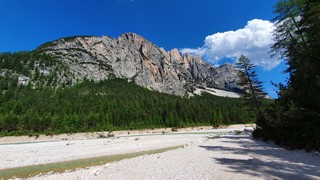
Let's discover together the "Rifugio Mietres" with this easy hike through the "Larieto" larch woods. Considering that it is a rather short walk, we want to offer you an optional detour, short but intense, to reach the "Forcella Zumeles," an amazing scenic point on Cortina d'Ampezzo.

This hike can be found on Tabacco Map 003, "Cortina d'Ampezzo e Dolomiti Ampezzane," and goes along Path 211, with a detour on Path 204. Alternatively, you can see our route on Google Maps by clicking here.
This short and relaxing walk is suitable for everyone, even untrained people, elderly and younglings. The optional detour to the scenic point of "Zumeles" is only for trained hikers, as it's quite physically demanding.
 Help us stay ad-free with a small offer.Donate now!
Path of the hike
The start of this hike is this parking lot, near the "Brite de Larieto." If you are unsure of how to reach it, we will describe it in depth down on the page in the chapter "How to Get There." Alternatively, clicking on the name will open the location on Google Maps.

Once you've parked your car, walk toward the restaurant. There you'll see a wooden sign that will show you Path 211 towards "Mietres."

The walk goes along the forest for about fifteen minutes, without ever becoming too demanding. The road is wide and the surface is quite smooth, so it's also suitable for children and elderly people.

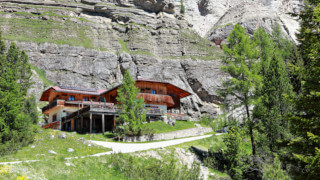
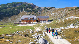
You will come across an intersection, marked by a wooden sign, indicating the "Rifugio Mietres" to the left. "Rifugio," in Italian, means mountain lodge. If your idea is to just take a short walk, go left towards "Mietres" where you can relax, drink or eat something, on the beautiful scenic terrace.

If you feel you want to walk a little more you can continue to the right, along Path 211, towards "Chiave" and "Cademai." The road will start to climb later, but it remains almost flat for a while. This is also the direction you have to take if you want to take the detour toward "Zumeles."

After walking about twenty minutes you will see an intersection between Path 204 and Path 211, it's easily identifiable because of the bench and the wooden signage.

Here you have to make a decision. Your first option is to walk toward the "Rifugio Mietres," and finish the walk. The second option is to walk aimlessly in the direction of the district of "Chiave," then turn around when you feel like it.

The third option is the hard one, that's also the more satisfying: take Path 204 and climb up to "Forcella Zumeles," to see a breathtaking panorama.

Initially the road climbs with a tolerable gradient, so you can tackle it even if you are not fully trained. After about twenty minutes uphill, the vegetation will begin to thin out, and the tall trees will change to low mountain pines.

At the end of the woods, remember to turn around to enjoy the beautiful panorama over Cortina. From here, you will have a privileged view on Mount "Tofana," Mount "Pelmo" and the entire Dolomite area.
If you have energy left or are used to walking in the mountains, you can continue further along the steep Path 204 and reach "Forcella Zumèles" If you are curious, "Forcella" is an Italian word that means mountain saddle. We don't want to show you too much with photographs, so as not to ruin the surprise, but the view is amazing. If you are exhausted, you can turn back towards the "Rifugio Mietres" at any given moment.

If you decide to continue, consider that the climb is really steep and that you may suffer from dizziness, because in some points the cliff is just at the side of the road. Anyway the effort will be amply rewarded by the panorama. Descend very carefully, being careful not to slip.

Once you reach the intersection between Path 204 and Path 211 turn left, to go back to the "Rifugio Mietres." If you want to eat here, it offers a wonderful terrace with a view and a simple menu suitable both for hikers and those who are looking for a good high-altitude restaurant with a very respectable wine list.

Alternatively you can go back to the beginning of the hike. Here you will find the restaurant "El Brite de Larieto," we could define it as high-end agritourism, which uses local products and offers good cuisine, but with prices that are definitely not the ones of agritourism.
The two mountain lodges are both very popular and, during the peak season, it would always be better to book, if possible.
Help us stay ad-free with a small offer.Donate now!
Curiosities
The name "Larieto" comes from the local dialect and literally means Larch forest. Larches are very common in Cortina d'Ampezzo, especially in the European Larch variant. The most fascinating characteristic of these trees is that they turn on a very intense yellow hue in autumn. If you have the opportunity to do this walk in autumn we assure you you will love it. The term "Brite" indicated the hut where the cheese was produced.

"Forcella Zumèles" is a crossroads of many mountain paths, as the one that goes to "Són Fórcia." On this road, on the evening of August 14th, during the celebration of the Assumption of the Virgin Mary into heaven, a large M-shaped bonfire is lit. It's visible from all over Cortina.
For those who want to make a big effort, "Zumeles" can also be reached from the center of Cortina. This hike is considered excellent training for those who want to train for Trail Running competitions, as it's possible to climb a difference in altitude of around 800 meters, 2,600 ft, in less than two hours.
Help us stay ad-free with a small offer.Donate now!
How to get there
The best way to reach "Larieto" is with a car. Once you arrive you will find a free, but definitely small, parking lot. If you don't want to have trouble finding a spot for your car, you should arrive early in the morning, before the other hikers and restaurant guests.
If you don't have a car, you can consider taking a taxi. From Cortina to "Larieto" the cost should be approximately €30. Considering that prices could vary a lot, both for the type of vehicle and the number of people, you should always ask for a quote. Taxis can be found both in Roma Square and at the bus station, or you can visit the Taxi official website.
Alternatively, you can take the bus in the direction of "Passo Tre Croci," with destination "Misurina." It is a seasonal bus, active from mid-June to mid-September. Unfortunately there is no stop nearby "Larieto," so you have to get off at "Rio Gere" and walk back for about one kilometer, a little more than half a mile.
If you don't want to walk along the state road, it is possible to follow a section of Path 211 which leads from "Rio Gere" to "Larieto." The road is well signposted and crosses the woods that you saw on the left of the road.
For further information we recommend you to contact the Seam ticket office at the bus station. Attention, as the bus is active only in some summer months and the ticket office may be closed during lunch hours.
If you need any information there is a tourist information office. It is located in the town center, near the church.
Help us stay ad-free with a small offer.Donate now!
Useful information
The walk from Larieto to Mietres can be done at any time of the year, even in winter, as the road is regularly groomed. In case of snow you should bring shoe crampons, to avoid slip on the ice. The hike to "Zumeles" is only practicable in summer, as it is not groomed and really steep.
If you decide to eat in one of the two restaurants, they are usually open for most of the year. If you don't want to have bad surprises it's always better to call: in low season to check actual availability and in peak season to book.
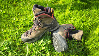
Hiking clothing is not required, but considering that most of the road is gravel, we recommended sportswear and good shoes, which should be sturdy. For the detour to "Zumeles" you need mountain shoes. Always carry a backpack with, at least, some water, a snack and a rain jacket. If you are new to hiking, you may want to read the page we wrote on how to tackle a mountain outing:
We want to emphasize that, in the Dolomites, there are rules to be followed. The main ones are:
- It is strictly forbidden to light fires.
- It is strictly forbidden to pick plants and flowers.
- Free camping is prohibited.
- It is prohibited to abandon garbage.
- It is mandatory to keep pets on a leash.
Always be responsible and, when in doubt, stop. CiaoCortina cannot be considered responsible for any damage to things or people, variations, wrong path,, errors or inconveniences that may occur along the route. For more information, click here.
Help us stay ad-free with a small offer.Donate now!
Conclusion
We hope you liked this page on the walk from "Larieto" to "Mietres" with an optional detour to "Zumeles." Before saying goodbye, we would like to mention that you can find other amazing hikes in Cortina and its surroundings by clicking here.
If you want to thank us you can read the page Support us. If you only want to suggest a change, propose something or just say hello, in the section contacts and info you'll find all the ways to reach us.