Overview
Map

Introduction
The hike that leads to "Plätzwiese," in Italian "Prato Piazza," starting from "Carbonin" is a very pleasant walk that is suitable for almost everyone. The path is an old military road, so there are no steep climbs for all the duration of the walk.

This hike can be found on Tabacco Map 010, "Dolomiti di Sesto," and goes adjacent to Path 37. Alternatively, you can see our route on Google Maps by clicking here.
Although it is a relatively easy hike, the length of nearly ten kilometers, six miles, makes it not recommended for elderly or younglings, who might get tired.
Some clarifications about language. The words "rifugio" and "hütte" are the Italian and Austrian German words for "mountain lodge." The vicinity of the South Tyrol makes it correct to name the locations both in Italian and German Austrian language. That's why we'll use both for some destinations, Italian first.

Path of the hike
The walk from "Carbonin" to "Prato Piazza (Plätzwiese)" goes along a path that leads to both the "Rifugio Vallandro (Dürrenstein hütte)" and the "Rifugio Prato Piazza (Plätzwiese hütte)."
This hike starts on this large parking lot, at the side of the road. If you are unsure of how to reach it, we will describe it in depth down on the page in the chapter "How to Get There."

Once you have parked the car, walk a little back, until you reach the starting point of the hike, an easily recognizable stone fountain with an arch.

On the board at the beginning of the path you can see a travel time of about two hours and a half. It is quite realistic if you are decently trained. On the board you can also verify the actual opening of the two mountain lodges, where you can stop to eat something at the end of your climb.

The road is fairly wide, not too hard to walk and without particularly steep climbs. There are some intersections by a steeper variant, an option which allows you to cut a few curves, slightly shortening the hike. Throughout this first part of the path you will enjoy the shadow of the forest, which will protect you from the sun.

The climb continues for about an hour and a half, always in the woods and always with a constant slope. During the uphill you will find a fountain, perfect for drinking some spring water and replenish the flasks.

Up to this point the hike has not been particularly scenic. Apart from a few small glimpses of the state road, from which you can understand how much elevation you have gained, there have not been particularly exciting moments. Don't worry, they will appear shortly.

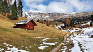
When the woods begin to thin away you'll see the large grassy pastures of "Prato Piazza (Plätzwiese)." From here the panorama will become more scenic. In about half an hour you'll reach the first goal of your hike, that is the "Rifugio Vallandro (Dürrenstein hütte)."

If you are very tired you can stop at this mountain lodge to drink or eat something. Once rested, you will have to decide whether you prefer to return toward the car, shortening the hike by an hour, or continue toward "Rifugio Prato Piazza (Plätzwiese hütte)," as clearly indicated by the wooden sign "Plätzwiese - Prato Piazza."

If you decide to proceed, a walk of about thirty minutes awaits you, always flat, with amazing views of the Mount "Croda Rossa d'Ampezzo" and the grassy pastures, peculiar to this area.

At the "Rifugio Prato Piazza (Plätzwiese hütte)" we ate a plate of pressed "canederli" on a bed of cabbage, accompanied by a good beer. This is a typical South Tyrolean dish, which they do very well here. You can also eat very well at the "Rifugio Vallandro (Dürrenstein hütte)," if you choose to stop there.

Since the weather was changing, we decided to go down as fast as we could, so we took the Path 37. This is a path that, for most of the time, overlaps with the road taken to ascend, but it cuts many curves.

Surely it's a funnier and faster route than the military track we climbed before. In the ascent it would be too steep and tiring, but for descent it's a good alternative. We recommend it both for those who want to shorten the route and for those who prefer to be a little more in contact with nature, but without the comfort of a gravel road.

If you decide to use our GPX map, we recommend disabling the alarms on the descent, as the poor GPS reception caused some smearing of the track.
Curiosities
The area of "Prato Piazza (Plätzwiese)," in addition to being famous for its mountain lodges and hiking routes, is remembered for its leading role during the First World War. During the climb you will have the opportunity to observe the remains of some military structures, including a war fort and a barracks, from which bombs were launched at the nearby Italian army.
In winter, thanks to the abundant high-altitude snowfall, the pastures of "Prato Piazza (Plätzwiese)" become a beautiful cross-country skiing trail. If you are a lover of this sport we recommend a visit, the track is quite easy, but the panorama is spectacular.
A beautiful hike starts at the "Rifugio Prato Piazza (Plätzwiese hütte)." It climbs up to the summit cross of "Monte Specie," from which you can see an unforgettable view of the "Tre Cime di Lavaredo," the Three Peaks of Lavaredo and the Eastern Dolomites. If you decide to tackle it, this hike will take you around three hours, for a gain in altitude of around 300 meters, almost 1,000 feet. The path is well marked and never too exposed.
If you would like to see this destination, but do not feel like committing to the hike, the "Rifugio Prato Piazza (Plätzwiese hütte)" can also be reached by car. It's about an hour's car ride from Cortina.
There is an alternative road to reach "Prato Piazza (Plätzwiese)," starting from Cimabanche and following the "chenòpi" path. This variant can be made for both the ascent and the descent, as they have the same arrival point and two relatively close starting points. This is a more scenic route, but you have to follow a rather steep path. Given the steep slope, we recommend it only to trained hikers. If you decide to come down this variant, you will arrive at the parking lot of Cimabanche, from which you will have to walk for about twenty minutes along the state road, towards Dobbiaco, to reach the "Carbonin" car park again, where you have left the car. If you prefer a more detailed description, we suggest you click on the page below, where we talk about it in depth:
How to get there
In order to reach "Carbonin" it would be better to have a car, so as to have the best flexibility in the time you want to arrive and leave.
The Parking lot to the "Rifugio Vallandro (Dürrenstein hütte)," our starting point, is free and quite big, but it's anyway advisable to get there early in the morning, to have more chances to find a free space. The parking lot is approximately a twenty minute drive from the center of Cortina.
If the parking lot is full, you can try to go back and park on one of the lay-bys along the road, but be very careful not to block the roadway, otherwise you might get a ticket.
If you want to use public transport, at the bus station of Cortina d'Ampezzo, you can take Bus No. 445 from Cortina to Dobbiaco and get off at the stop at "Carbonin." Generally there's a bus every couple of hours, but in the peak season there may be more. Considering the seasonality, ve recommend asking the ticket office at the bus station more precise information or alternatives. It may be closed during lunch hour.
If you don't have a car you may also consider a Taxi. From Cortina to "Carbonin" the price should be, approximately, 50€, but it is better to ask the price beforehand, as this is a very rough estimate. You can find a Taxi both in Piazza Roma, at the bus station or using their website.
For any doubts you may have, you can consult the Tourist Information office in the center of Cortina.
Useful information
The hike from "Carbonin" to "Prato Piazza (Plätzwiese)" can be taken at any time of the year, even in winter, as the road is regularly groomed. In case of snow it is advisable to take crampons to put on your shoes, to avoid slipping on ice. Consider that, at certain times of the year, the snow melting makes the ground a bit muddy and in some places it is possible to find snow.
Unfortunately, every season is different and it is not possible to know in advance how much it will snow when the snow will melt.
If you decide to eat at one of the two mountain lodges, consider that, during low season, it is always best to call to verify the actual opening. Even though the facilities are open most of the year, it's better to check, to avoid bad surprises.
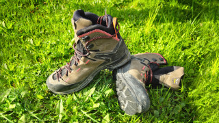
When facing a hike, we always recommend that you use appropriate clothing, starting with your shoes, which should be sturdy. Always carry a backpack with, at least, some water, a snack and a rain jacket. If you are new to hiking, we recommend you read the page we wrote on how to tackle a mountain outing:
We want to emphasize that, in the Dolomites, there are rules to be followed. The main ones are:
- It is strictly forbidden to light fires.
- It is strictly forbidden to pick plants and flowers.
- Free camping is prohibited.
- It is prohibited to abandon garbage.
- It is mandatory to keep pets on a leash.
Conclusion
We hope you liked this page about the hike from "Carbonin" to "Prato Piazza (Plätzwiese)." Before saying goodbye, we would like to mention that you can find other amazing hikes in Cortina and its surroundings by clicking here.
If you want to thank us you can read the page Support us. If you only want to suggest a change, propose something or just say hello, in the section contacts and info you'll find all the ways to reach us.