Overview
Map

Introduction
The hike that heads to Lake Ajal starting from Lake Pianozes is an amazing walk surrounded by nature. In less than an hour you can see the two most touristic lakes in Cortina. Both of them offer bar and restaurant service.

This hike can be found on Tabacco Map 003, "Cortina d'Ampezzo e Dolomiti Ampezzane," and goes along Path 430. Alternatively, you can see our route on Google Maps by clicking here.
It is a relatively short walk, but the path is in a constant climb. Because of this, it is not recommended for children and people that have problems walking uphill.

Path of the walk
The hike to Lake Ajal from Lake Pianozes starts at the restaurant Pianozes, on the shores of the lake with the same name. If you are unsure of how to reach it, we will describe it in depth down on the page in the chapter "How to Get There."

Leave Lake Pianozes behind, then walk north, in the direction of "Campo di Sotto." A few meters ahead you will find a small road that goes up to the left, you can see it, highlighted by a white arrow, in the picture below.

A few meters later you will reach the locality known as "Parù de Col," here there's a big parking lot, from which starts a lot of different hikes. If you plan to get there with your car, you should park there.

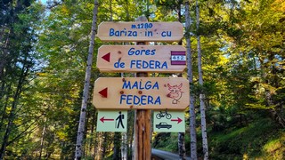
After the parking area, in front of you, you'll find a fork. You have to take the road to the right, the steeper one, as highlighted in the picture below. The road to the left would lead to "Malga Federa," and to the wonderful hike named "Ra Góres de Fedèra," but we'll tell you about it later, in the section curiosities.

The first part of the road is asphalted, after a little you will see a "rough road" road sign, which indicates the beginning of the white road. This is a warning for vehicles. Since the road is open to traffic, pay attention to the cars. Once you have tackled the first climb, short but intense, the walk continues along the woods, a little less steep, without any particular deviations.

After about thirty minutes you'll find an information board and a crossroads. You are about halfway through the walk. If you want to rest a little, you could use the opportunity to learn something new about the local forest, by reading the interesting information in the info table, but honestly, we can't remember if there is an English translation.

For those who are curious to know where the other two roads goes, by going left you would reach a private log cabin in the woods, known as "Cejura Granda." The road to the right would bring you to the district of "Mortisa," from which it would be possible to reach the center of Cortina.
You have to go straight, heading towards the wooden bridge, along the only road that's not barred by poles.

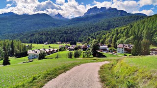
Once you have crossed the wooden bridge the road goes on a medium slope for about fifteen minutes. This is the only slightly panoramic point, but it's nothing special, your effort will be rewarded later, by the view of the lake, which is truly very suggestive.
Continue for another ten minutes, along the final stretch, which is flat. At the last crossroads turn left, towards "Ristorante Lago d'Ajal." The intersection is very well signposted and you can clearly see the roof of the restaurant, on the left, slightly hidden behind the rise in the ground.

The restaurant is under new management and has recently been renovated. Once you reach it, you can stop to eat or drink something, the manager is very friendly, the place is very cozy and the dishes are simple, but good. If it is too early to eat, maybe you can have a look around the area.
If you want to take a look in the vicinity you can visit the "Ciòu del Conte" dam. This dam creates an artificial lake, which supplies water to the power plant in "Campo di Sotto." You may have noticed it, at the beginning of the road towards Lake Pianozes. The path to the artificial lake is well signposted, leaving the lake behind you, go straight at the crossroad, along the flat road.

Alternatively, at the crossroads, you could take left and climb the slope closed by the pole. In about 15 minutes you will reach the "Cason del Macaròn," a private wooden hut, owned by the "Regole d'Ampezzo." It is given in usufruct to eligible residents. Here you can find a fountain where you can drink fresh spring water. From this point you can also reach "Pezié de Parù," and "Malga Federa," but will not explain those hikes on this page.

If you decide to return to Lake Pianozes you will find the restaurant of the same name, but consider that it's quite prestigious and with prices that are not exactly popular. In the months of July and August, on the opposite shore of the lake, you will find a small wooden kiosk where you can eat sandwiches, drinks and ice creams. It is way cheaper and it also offers the possibility of renting deckchairs.
Curiosities
The parking lot of "Parù de Col" is the starting point of other hikes, but the best, for sure, is the one known as "Ra Góres de Fedèra." This is a newly built equipped path, where you can walk up the gorges carved out by the river known as "Ru de Fedèra." For more information on this hike we invite you to read our page, you can see it below:
In 2021 the Alpine Guides and the "Scoiattoli" of Cortina built a walkable path around Lake Ajal. Curiously it was not possible to walk all around the shores of the lake before.
The manager of the Restaurant Ajal is a curling enthusiast. For this reason, in the winter of 2021 and 2022, he set up a track on the frozen lake to allow customers to have fun practicing this sport.
The artificial lake of "Ciòu del Conte," in addition to supplying the power plant with water, is also an excellent fishing basin. If you are passionate about this sport, and you have a valid license, it is possible to fish excellent trout in the lake.
How to get there
Lake Pianozes, the starting point of our hike, can be easily reached by the town center. The first possibility is a beautiful and scenic walk, lasting about forty-five minutes, along a road surrounded by greenery called "Convento." If you don't mind extending the walk, it's really worth it.
We have described this beautiful walk, in-depth, on a dedicated page, which you can read by clicking below:
If you want to take the car, you can leave your vehicle in the big and free parking lot of "Parù de Col." Considering that this is the starting point of many hikes, in peak season, it is a good idea to arrive early, so as not to find the parking area full. The car ride will take you about fifteen minutes.
Alternatively, you can also consider taking the bus, in this case you have to take Bus No. 2 from Roma Square to the bus stop at "Campo di Sotto." From there you can reach the lake in a ten minute walk uphill. For further information we recommend you to contact the Seam ticket office at the bus station.
Finally, you could take a taxi. From the town center to Lake Pianozes the cost should be approximately €20. Considering that prices could vary a lot, both for the type of vehicle and the number of people, you should always ask for a quote. Taxis can be found both in Roma Square and at the bus station, or you can visit the Taxi official website.
If you need any information there is a tourist information office. It is located in the town center, near the church.
Useful information
The hike from Lake Pianozes to Lake Ajal could be done at any time of the year, but it is necessary to explain the situation. The Lago d'Ajal Restaurant has been closed during the winter of 2023/2024. For this reason the snow on the road has not been beaten. If the management decides to open next winter, the snow on the road will be regularly beaten. In any case, if the snowfalls are not heavy, the road should be walkabe without too many problems. In the winter season it is advisable to bring crampons to apply on shoes, to avoid slipping in case of ice.
The Pianozes Restaurant is open for most of the year, the kiosk on Lake Pianozes is aopen only in July and August. If you don't want to have any bad surprises, it's always better to call first to check if the restaurant is actually open.
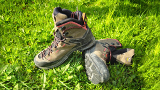
The use of hiking equipment is not required, but considering that the road is mostly gravel, you should wear sports clothing and shoes. It's always advisable to have a backpack with at least some water, a snack and a rain jacket. If you are not used to mountain hikes, before venturing, we recommend you read the page below:
We want to emphasize that, in the Dolomites, there are rules to be followed. The main ones are:
- It is strictly forbidden to light fires.
- It is strictly forbidden to pick plants and flowers.
- Free camping is prohibited.
- It is prohibited to abandon garbage.
- It is mandatory to keep pets on a leash.
Conclusion
We hope you liked this page about the walk from Lake Pianozes to Lake Ajal. Before saying goodbye, we would like to mention that you can find other amazing hikes in Cortina and its surroundings by clicking here.
If you want to thank us you can read the page Support us. If you only want to suggest a change, propose something or just say hello, in the section contacts and info you'll find all the ways to reach us.