Overview
Map

Introduction
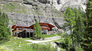
"Ra Góres de Fedèra" is a very beautiful hike that leads to "Malga Federa," a splendid mountain lodge, starting from "Parù de Col" parking area, near to the Pianozes Lake. The walk follows the stream "Ru de Fedèra" and will allow you to admire some beautiful waterfalls and the gorges that have been dug by the water along its descent towards the "Boite" Stream, of which it's a tributary. The name, in the local dialect, means the gorges of "Fedèra."

You can find this hike to "Ra Góres de Fedèra" on the Tabacco Map 003 - "Cortina d'Ampezzo Dolomiti Ampezzane," along the equipped path which runs alongside Path 432. It is a recent construction path, it may not be marked on older maps. Alternatively, you can see our route on Google Maps by clicking here.
Although this hike is generally considered as suitable for everyone, we preferred to categorize it as difficult, because of its length, of the strong difference in height and because there is a tiny iron path that is optional, extremely simple and well equipped.
 Help us stay ad-free with a small offer.Donate now!
Path of the Hike
First, you have to reach the free parking lot of "Parù de Col." If you are unsure of how to reach it, we will describe it in depth down on the page in the chapter "How to Get There."
Start going up the road, keeping left at the first intersection. Follow the signs for "Malga Federa," until you reach this parking with a pole that blocks cars from passing. You could also consider parking here, but the road is very narrow, steep and bumpy, we discourage it.

Continue along the asphalt road for about fifteen minutes. During peak season this section of the road is closed to traffic, but still pay attention to off-road vehicles heading towards "Malga Federa" and "Croda da Lago."

When you find the wooden sign "Barìza in cu m. 1280" you have to turn left, following the direction for Path 432 "Ra Góres de Fedèra" and "Malga Federa." This first part of the route is newly built, the old road was rather anonymous, this variant is much more characteristic.

After a short walk in the woods, a waterfall will appear on the horizon. From there you can see the aided path 432. Tackle the first climb, enjoy the view, but conserve your energy, as it is only the first climb of many.

Once you pass the small waterfall you will come across a wider gravel path. Here you have to turn right and walk along the woodland road, until you meet the asphalt again. Although there are some intersections along the route, the road to follow is always well signposted.

Once you reach the wooden sign "Col Purin m. 1350," turn left, continuing to follow Path 432 "Ra Góres de Fedèra" towards "Malga Federa."

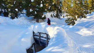
The hike continues along the path in the woods for a few hundred meters, almost a thousand feet, until you find a wooden bridge. From here the path begins to become a little steeper, with small embankments built with logs and terrain.

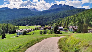
After this climb an amazing panorama of Cortina will appear in front of you. Here you will find some wooden benches where you can stop, if you need to take a breath or you want to enjoy the panorama.

Shortly after continuing your walk you will see a crossroads in front of you. Here you will have to decide how to continue the hike:
- If you take the left, you will take the aided path "Gores." It is the one we chose, which runs alongside the stream, along a small gorge, to an easy via ferrata, with a metal walkway overhanging the water and a steel cable that you can hold.
- If you don't want to face the aided path, although simple, take the intersection to the right. This is the direction for the easy path, which will take you along the woods, avoiding any technical passages.

We would like to explain that the definition via ferrata is way exaggerated: it is not a scary trait, nor a ravine. It is a series of iron and rock steps on which to walk overhanging above the stream. It's certainly not that difficult, but avoid it if you are with small children or have limited mobility. One of us suffers terribly from vertigo, but he had no problem making this passage. There's an information panel that says that it's mandatory to have a harness and carabiners.

After about an hour and a half you'll reach the bridge of "Fedèra," at an altitude of 1,600 meters, 5,250 ft. By now you have already climbed three hundred meters, one thousand feet, there are still two hundred meters, seven hundred feet, to reach our destination.

Continue to the second part of the hike, which is marked by the wooden sign just before the bridge. Keep following the directions of the pedestrian route, the Path 432 "Ra Góres de Fedèra."

This is undoubtedly the most beautiful part of the walk because, running along the stream, you can observe the waterfalls and the gorges carved by the force of the water, from which the path of the gorges of the "Fedèra" Stream.

After crossing the bridge, walk a little through the woods. You will then descend into a gorge, where you will find a terrace overlooking the stream below. Immediately afterwards, you will climb a suggestive stair, which will take you along the stream bed.

From here you have to climb a steel bridge, at the end of which you will reach a point full of blueberry plants. This is the last equipped passage of the hike, as from here the trail will become a normal path in the woods.

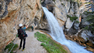
After walking about fifteen minutes you will reach the waterfall of the "Fedèra" Stream, this is the most characteristic point of the whole hike. Here you can stop to take a picture or catch your breath before the last trait of the walk.

The path continues along the stream, with some views of small natural pools and very beautiful waterfalls. When the forest begins to thin out, in the distance, you will see the Mount "Bèco de Mesodì," a very characteristic peak. The hike of the gorges of "Fedèra" is almost over.

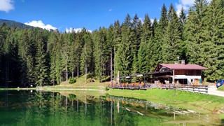
With one last effort you will reach the end of the woods, which gives way to the pastures surrounding "Malga Federa." Here you can stop for a drink, or to eat something. During the peak season this mountain lodge is open every day, while in the low season it is usually only open on weekends.
You will have to decide whether to go back retracing the same route you took to climb, or if you want to go down following the asphalt road, as in our case. This second option is much faster, but certainly less beautiful and scenic. The asphalt road is also open to limited vehicle traffic.
Help us stay ad-free with a small offer.Donate now!
Curiosities
"Ra Góres de Fedèra" is a relatively new path: the first part, the lower one, was inaugurated in 2021. The second part, created by a collaboration between the "Regole d'Ampezzo" and the Sci Club 18, was inaugurated in 2019. In the past this path was only known by hunters, but thanks to the desire to enhance the area and to the collective effort, this highly naturalistic hike has been created. It has been a great success among tourists and residents, and also the owner of the mountain lodge is happy.
"Malga Federa" has benefited greatly from the creation of this route. Now it may be considered as a destination, previously it may have been considered as an intermediate stop by the tourism headed towards Lake "Fedèra." If you still have some energy left, from "Malga Federa," it is possible to reach the "Rifugio Palmieri" which overlooks the splendid lake. This is a walk that takes approximately another forty five minutes uphill, with a difference in altitude of about two hundred meters, six hundred feet, with a two kilometers walk, one mile and a quarter.
 Help us stay ad-free with a small offer.Donate now!
How to Get There
The free parking lot of "Parù de Col," the starting point of our hike, can be easily reached in different ways. The first option is to take the car. Considering that this is also the starting point of other hikes, during peak season, it is a good idea to arrive early, so as not to find the parking area full. The car ride will take you about fifteen minutes.
Alternatively, you can also consider taking the bus, in this case you have to take bus n°2 from Roma Square to the bus stop at "Campo di Sotto." From there you can reach the lake in a ten minute walk uphill. For more information and to purchase tickets, you should contact the ticket office, which is located in the same office as the Tourist Information Center. It may be closed during lunch.
If you prefer to move on foot, there is a splendid road surrounded by greenery, called "Convento," that can bring you there in around forty five minutes. If you don't fear extending an already demanding walk, it's really worth it.
We have described this beautiful walk, in depth, on a dedicated page, which you can read by clicking below:
Finally, you could take a taxi. From the town center to Lake Pianozes the cost should be approximately €20. Considering that prices could vary a lot, both for the type of vehicle and the number of people, you should always ask for a quote. Taxis can be found both in Roma Square and at the bus station, or you can visit the taxi official website.
If you need any information there is a tourist information office. It is located in the town center, near the church.
Help us stay ad-free with a small offer.Donate now!
Useful information
The hike "Ra Góres de Fedèra" can be done only in summer, due to some passages which, in the presence of snow and ice, could become quite dangerous. Usually the most suitable months are those between June and October. This is a slightly conservative estimate, but every season is different, so it is not possible to know exactly when it will snow and when the snow will melt.
If you want to reach "Malga Federa" in winter you can climb the road on foot and then go down with the sled. The snow on the road is regularly packed by people walking and with a snowcat. We describe this alternative in the page about the winter hikes, which you can read below:
If you decide to eat at "Malga Federa" the structure is open on the weekends for most of the year and the whole week during peak season. If you don't want to have problems it is always better to call before, to check the actual opening and availability.
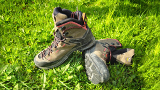
When facing a hike like "Ra Góres de Fedèra," it is advisable to wear shoes suitable for the mountains, with a well-defined sole, as you will certainly find yourself crossing slopes with mud. If you want to be compliant it would be a good idea to also have a harness and a pair of carabiners. If you don't have much experience mountain hikes, before venturing, we recommend you read the page below:
We want to emphasize that, in the territory of the Dolomites, there are rules to be followed. The main ones are:
- It is strictly forbidden to light fires.
- It is strictly forbidden to pick plants and flowers.
- Free camping is prohibited.
- It is prohibited to abandon garbage.
- It is mandatory to keep pets on a leash.
Always be responsible, and when in doubt, stop. CiaoCortina cannot be held responsible for any damage to things or people, variations, wrong paths, errors, or inconveniences that may occur along the route. For more information, click here.
Help us stay ad-free with a small offer.Donate now!
Conclusion
We hope you liked this page on the hike of the gorges of "Fedèra." Before saying goodbye, we would like to mention that you can find other amazing hikes in Cortina and its surroundings by clicking here.
If you want to thank us, you can read the page Support Us. If you only want to suggest a change, propose something, or just say hello, in the section Contacts and Info, you'll find all the ways to reach us.