Overview
Map

Introduction
The Lower Fanes Falls Hike is quite a challenging walk, with a length of about ten kilometers, six miles, that starts and ends in the locality of Fiames. The Hike to the Fanes Waterfalls is a wonderful walk that will take you about three hours, with a difference in altitude of about 550 meters, 1,800 feet.

This hike can be found on Tabacco Map 003, "Cortina d'Ampezzo e Dolomiti Ampezzane," and goes along Path 10, with a deviation on the "Canyons and waterfalls" trail. Alternatively, you can see our route on Google Maps by clicking here.
This hike we are going to describe is suitable for everyone that is reasonably trained, but it can be made more challenging by taking an optional variation that needs climbing harnesses and carabiners. Alternatively it is also possible to shorten the length, while still remaining a scenic and satisfying walk. On the page, however, we will describe all the variants.
 Help us stay ad-free with a small offer.Donate now!
Path of the hike
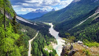
The Lower Fanes Falls Hike begins at the free parking lot of Ampezzo's Dolomites Park. If you are unsure of how to reach it, we will describe it in depth down on the page in the chapter "How to Get There."

Once you've parked your car head towards the tourist information wooden hut, cross the bar that blocks the cars and start walking along path 10. After a few meters, on your right, you'll see a suggestive gorge, called "Forra del Felizon," that has been dug by the flow of the "Felizon" river,

After about one hundred meters, three hundred feet, you will see the intersection of the "Felizon" Bridge. Take the road to the right and continue along Path 10 towards the Waterfalls, Valley of Fanes. In Italian we call them "Cascate di Fanes," it may help you with the signposting.

The walk continues on an asphalt road for about thirty minutes, alternating uphills with downhills. Along this part of the walk you will see some nice botanical signs describing the plants that grow along the road, as well as some benches where you can stop and relax.

You will see a small bridge, proceed along the asphalt road for ten minutes more. You will end up in the intersection of "Pian de Loa," it is easily recognisable by the bench and the signpost "Pian de Loa, 1349 mt." Take the road to the right, in the direction of "Cascata - Belvedere - Sent. dei Canyons e delle Cascate." It means Fanes Falls, viewpoint, path of canyons and waterfalls.

We decided to take this newly created detour to allow you to see the Fanes Falls from a new and very scenic perspective, and then turn back and continue from here to the bridge called "Ponte Outo." For those who wish to shorten the walk a little, it is possible to go directly to the left, in the direction of the "Ponte Outo."
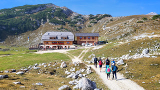
So we are at the intersection of "Pian de Loa." Take the road right and walk along the flat gravel road for about ten minutes. You will reach a large glade with a small mountain hut, called "Cason de Pian de Loa."

From here you need to take the left, following the signs towards "Cascata di Fanes - Belvedere - Sent. dei Canyons e delle Cascate." From here the path enters the woods, gradually becoming narrower and slightly steeper, but always remaining clearly visible.

After about half an hour, the path will make a sharp bend to the right, becoming steeper. You have almost arrived at the viewpoint, ten more minutes and you will see it on the horizon.

Once you've reached the viewpoint, the majestic Lower Fanes Waterfall will stand out in front of you. If you have a fear of height, the area has been secured, and there is a railing to make you feel safe.

If you have the necessary equipment for a via ferrata you could continue along the narrow serpentine canal that you just left behind. This, in fact, is the canyon and waterfall trail of which we talked about earlier.

This path descends to the iron bridge that you can see further down, at the base of the waterfalls, and then climb up until passing right behind the waterfall. We want to reiterate that it is a technical and rather dangerous route, recommended only for expert hikers, equipped with climbing harnesses, carabiners and hiking shoes.

Our itinerary is much simpler, suitable for those looking for a more relaxing hike, for those with children, or for those who suffer from vertigo. Don't worry about the missed opportunity, even with our variant it will be possible to pass behind the waterfall, along the optional via ferratas "Giovanni Barbara."
Retrace your steps until you reach the intersection of "Pian de Loa, 1349 m," from where we took this detour. It should take you about half an hour. If you are tired, or you are not interested in passing under the waterfall, from here you could go back to the car.
Once you reach the crossroads, turn right, following the direction "Ponte Outo" - "Valle di Fanes." It means "High Bridge, Fanes Valley." From here you would probably stop for a moment to take a look at the "Rü de Fanes," the river just behind the crossroads, which could be a beautiful place to rest a bit and gather your energy.

Once you cross the river, you will find a road that goes into the woods. Initially it will be flat, but the slope will progressively increase, but it never becomes excessive. After about thirty minutes, you will see the bridge called "Ponte Outo."

The bridge stands on a ravine dug by the river "Rü de Travenanzes." The name "Ponte Outo" literally means high bridge, in the local dialect. Now that you're on it, you probably haven't any doubt about the reason for this name.

After you've observed the view, continue another hundred meters, three hundred feet, until you reach a rest area with a bench. From here you can enjoy a breathtaking view of the valley below. If you look carefully, you can even see the viewpoint you went to before.

Our hike ends here, but if you want a final thrill, from here, you can take the via ferrata "Giovanni Barbara," indicated by the sign: "Sentiero attrezzato alla cascata," that means "Aided path to the waterfall."

This is an easy but very exposed path, to be tackled with the help of a climbing harness, It is strongly not recommended for those who suffer from vertigo or those who accompany children. If you decide to tackle it, in ten minutes you will reach the low Fanes waterfall, which offers the possibility of passing under the waterfall. Remember to bring a waterproof jacket, as the temperature is significantly lower that on the path and the mist will give you a nice shower.
Once you are happy, return to the rest area, from there retrace the road until you reach the car again. It will take you approximately an hour.
If you still have some energy, you can also consider climbing up to the high waterfalls of Fanes. We will talk about this hike down below, in the chapter about the curiosities.
Help us stay ad-free with a small offer.Donate now!
Curiosities
The hike on this page is the low waterfalls of Fanes. If you want to tackle a slightly more challenging walk, once you reach the bridge called "Ponte Outo," you can continue along Path 10 and reach the ring of the high waterfalls of Fanes.
There is a legend around "Ponte Outo," translated as "high bridge," it narrates the exploits of the Great Bracun. This knight seems to have been the noble "Francësch Wilhelm de Brach." He had to go to visit his girlfriend in "Podestagno," a nearby location. The owners of the nearby pastures were pissed by his continuous riding on the lands, so they decided to play a cruel joke on him. After cutting the supports of the bridge on the "Rü de Travenanzes," the shepherds hid to see the knight fall disastrously into the ravine. Thanks to a brilliant intuition, the Great Bracun understood that there was something strange, so he spurred his steed and, with a powerful leap, he crossed the tampered bridge, thus entering legend.
During your hike you may have noticed that some trees have been carved by the black woodpecker. It is the largest specimen in Europe, it uses its strong beak to dig the wood in search of insects, contributing to the control of tree parasites. This bird had almost disappeared from Cortina, but it has returned to populate the Ampezzo woods, including those you have just walked, in the last decades. The most affected tree can be seen just before the intersection of "Pian de Loa," marked by a descriptive sign.
Help us stay ad-free with a small offer.Donate now!
How to get there
Our version of the walk of the "Lower Fanes Falls" begins at the free parking lot of the Ampezzo's Dolomites Park, near the small wooden house that serves as the Park Information Point. The best way to get there is with your car, from the center of Cortina, you will need around 15 minutes.
As this is the starting point of many hikes,you should get there early in the morning, if you want more chances to find a free spot, if it's peak season. If you can't find a free parking space there's a second parking lot that might go unnoticed, located exactly here.
Another solution might be to take Bus No. 1 from Cortina's bus station and get off at the "Hotel Fiames," which is also the end of the line. From here you can take a wooded road toward the north which, in about thirty minutes, will take you to the car park. The road can be easily spotted from the bar blocking the traffic and from the sign that says "Bosco dell'Impero," which indicates the Val di Fanes.
For more information about the buses or to purchase tickets, you can contact the ticket office at the bus station. It may be closed during lunch hours.
This walk is already quite challenging, but you may still decide to walk from the town center to the starting point of the hike. In this case, you'll need to walk two hours more along the walk known as the former railway.
We have described this pleasant walk in a specific page, which you can visit by clicking below:
If you don't have a car you may also consider a Taxi. From Cortina to "Fiames" the price should be, approximately, 30€, but it is better to ask the price beforehand, as this is a very rough estimate. You can find a Taxi both in Piazza Roma, at the bus station or using their website.
For any doubts you may have, you can consult the Tourist Information office in the center of Cortina.
Help us stay ad-free with a small offer.Donate now!
Useful information
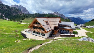
This is one of the few hikes that we describe that does not have a mountain lodge to welcome you at the arrival. We advise you to prepare a packed lunch, or plan the walk on a full stomach. If you want to eat out, in Fiames, you will find a nice place, the "Hotel Fiames," where you can eat something both inside or on the terrace. Alternatively, you can also stop at the "Chalet Spiaggia Verde," where you can drink or eat something and you will also possibly rent a sunbed to relax on the banks of the Boite river. We have never tried the restaurant under the new management. Although it is always crowded during peak season, it may be advisable to read some reviews first.
The walk to the lower waterfalls of Fanes and the small via ferrata behind the waterfall are not practicable in winter and are not recommended in case of rain. The rain makes the surfaces slippery, considering that some points are exposed, it's a good idea to avoid it. In winter the ice created by the waterfalls makes the route very dangerous, furthermore the cross-country track crosses the first part of the route and, by regulation, it is forbidden to walk or use snowshoes on the ski slopes.
The best period to do this hike is summer, as the presence of nebulized water will cool you off from the high temperatures. This walk is also very beautiful in spring, thanks to the thaw that supplies the waterfalls with water. The best month for the high water flow is probably May, but unfortunately it is not possible to know in advance when the snow will melt.
Even though this hike is pretty simple, if you avoid the via ferratas, we always recommend that you use appropriate clothing, starting with your shoes, which should be sturdy. Always carry a backpack with, at least, some water, a snack and a rain jacket. If you are new to hiking, we recommend you read the page we wrote on how to tackle a mountain outing:
We want to emphasize that, in the Dolomites, there are rules to be followed. The main ones are:
- It is strictly forbidden to light fires.
- It is strictly forbidden to pick plants and flowers.
- Free camping is prohibited.
- It is prohibited to abandon garbage.
- It is mandatory to keep pets on a leash.
Always be responsible and, when in doubt, stop. CiaoCortina cannot be considered responsible for any damage to things or people, variations, wrong path,, errors or inconveniences that may occur along the route. For more information, click here.
Help us stay ad-free with a small offer.Donate now!
Conclusion
We hope you liked this page on the hike to the Lower Fanes Waterfalls. Before saying goodbye, we would like to mention that you can find other amazing hikes in Cortina and its surroundings by clicking here.
If you want to thank us you can read the page Support us. If you only want to suggest a change, propose something or just say hello, in the section contacts and info you'll find all the ways to reach us.