Overview
Map

 Zero cookies, ads, and popups. Enjoying it? Buy us a coffee.
Introduction
Let's discover together this pleasant walk from the center of Cortina all the way to San Vito di Cadore. Despite its length of twelve kilometers, or seven miles and a half, the route is an enjoyable walk with only a minimal gradient, mostly on paved ground. If you plan your timing well, you can even return by bus.
The road partly follows the route of the former railway, along one of the most scenic sections of the Dolomites cycle path, and partly the ancient Strada Regia d'Alemagna, which in medieval times connected Venice with Augsburg, capital of Raetia, in Germany.

Although the path is always clear and well signposted, you can still follow our Google Maps route by clicking here.
 Have you seen our new Instagram page? Come follow us.
Path of the Walk
The walk towards San Vito, in the way we've selected for you, begins near the departure station of the Faloria Cable Car, which is the most convenient point to join the route of the former railway from the center of Cortina. From here, take the bridge that rises above the main road.
To avoid spoiling the surprise, we've selected photos which are ideal to make you understand the route, but without revealing too many panoramic views. Given how close this walk is to the town center and how easy it is, we prefer to leave you the discovery of the panoramas.

The walk continues gently, intersecting Via Menardi and then Via Faloria. At the end of a long, straight stretch, a couple of bends will signal your arrival in the hamlet of Cojana, where you'll find a traffic light; by pressing the button, you'll be able to cross the main road safely.

The following part of the walk is surrounded by greenery and offers spectacular views of Mount Faloria, Antelao, and the Cinque Torri. By this point, the walk will have taken you around thirty minutes.

As you continue, keep the Hotel Rosapetra on your left and go straight at the two next junctions, always following the cycle and pedestrian route; you can refer to the signs if you have any doubts. In about ten minutes you'll reach the Zuel's former railway tollhouse.

From here, continue alongside the state road, also known as SS51 Alemagna, for about one kilometer, or just over half a mile. You have nothing to worry about: there's a reassuringly solid guardrail protecting you from cars.
Once you reach the junction for Pian da Lago, turn right and head downhill, following the signs for the Dolomites cycle path, marked on the signs as E1. This small detour is necessary to avoid walking along the main road, which in the next section has no protections for pedestrians.

At the end of the descent you'll find the Pian da Lago cross, where you'll go straight, keeping the warehouse with the sign Carrozzeria on your right. After passing the building, you'll need to sharply turn left, as clearly indicated by the cycle path signs, and head up the gravel track.

Once you reach the locality of Acquabona, you may choose to stop at the Area 51 bar for a break or simply cross the village and continue briefly through the woods in the direction of the state road.

Now you need to walk on the side of the state road for two hundred meters, or six hundred feet. After that, take the road that slopes gently to the right, moving away from the state road. As you continue, the surroundings gradually become more wooded.
You may have heard about the landslide that caused several problems for local traffic. If you look to your left, you can clearly see the path of one of these debris flows.

From here, the unpaved road continues gently through the woods, offering stunning views of Mount Antelao. While walking straight, you may want to keep to the edge of the road to leave space for passing bicycles, which are quite frequent on this stretch.

In just over an hour and a half, you'll reach "Dogana Vecchia," a locality whose name can be translated as "The Old Border Customs House." It's so called because it has been the border between the Kingdom of Italy and the Austro-Hungarian Empire for centuries until the end of the First World War.
After passing the few buildings here, the road continues, paved, towards San Vito di Cadore.

The route continues through the woods, parallel to the state road, for another forty minutes, alternating between gravel and asphalt.
You'll know you've reached the locality of Chiapuzza when you see the Calcestruzzi Dolomiti plant, a facility that processes local gravel. There's also an underpass that allows you to cross below the Alemagna Road safely.

From here, the path rejoins the route of the former railway line, becoming wider and even easier to walk.
In the distance, the center of San Vito will come into view, and looking down, you can spot Lake Mosigo, which has been the set of two seasons of a popular Italian TV serie; if you are curious, the name is Un Passo dal Cielo.
From here you need about half an hour to end this walk. The first trait is through the woods; after passing the small railway tunnel, you'll keep walking among the houses that mark the entrance to the town, with the bell tower appearing in the distance.

Our interpretation of this walk from Cortina to San Vito ends when you reach the underpass leading down to the small square in the center of San Vito. It should have taken you approximately three hours.
If you're planning to return by bus, be sure to plan both your pace and the timetable carefully. The stop is the small wooden shelter you'll see on your right. We come back to this topic in more detail a little later in the page, in the chapter "How to Get There."

Once you arrive in San Vito, you can take the opportunity to visit the Parish Church, dedicated to Saints Vito, Modesto, and Crescenzia, or stroll through the shops in the town center, located just a little further ahead.

In our case, we took the chance to visit Lake Mosigo, which can be reached with a ten-minute walk from the center.
 No AI, every single text is written by us. Want to support the site?
Curiosities
This walk doesn't have a real endpoint. You can turn around and retrace your steps at any time, or if you feel to walk further, the former railway continues for another twenty-two kilometers, or thirteen miles, all the way to Calalzo di Cadore.

The Dolomites Railway was a narrow-gauge mountain railway that connected Calalzo di Cadore with Cortina d'Ampezzo and Dobbiaco, operating from 1921 to 1964. The railway played a key role in the tourism development of Cortina and the Dolomites. The line crossed spectacular landscapes, with numerous bridges and tunnels, offering amazing views of the Dolomites and the Cadore Valley. Despite its initial success, the road transport was more and more common and the maintenance prices grew constantly, bringing to its closure in the 1950s. Another reason that brought it to its closure was certainly the fact that it was a narrow-gauge line. The costs of converting it to standard-gauge tracks would have been enormous.

This road was known in the past as the "Strada Regia d'Alemagna," which means "The Royal Road of Alemagna." During medieval times it connected Venice with Augsburg, a town in Germany funded by the Romans. Along its route, travelers could find several hospices, including the Ospitale Inn and Restaurant, which has been in operation since the 11th century.
There were also some fortifications along this ancient road; between them, the Castle of Botestagno held significant strategic importance, and its ruins can still be visited today. We discussed both of these places on the page:
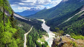
As mentioned earlier, the road connecting Cortina and San Vito has been affected by debris flows of varying intensity. During the last few summers, the traffic on the main road has been blocked many times, sometimes for a few hours, sometimes for several days.
The situation is constantly monitored, and traffic lights connected to sensors will become red in case of any ground movement. In any case, we strongly advise against using this road during severe thunderstorms. If you are on foot and it starts raining, it is definitely safer to take the forest road on the other side of the river, which is closed to traffic.
 We keep you company without ads. Care to buy us a spritz?
How to Get There
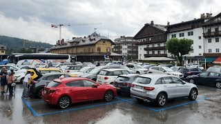
This walk to San Vito starts from the center of Cortina, so you shouldn't have any difficulty reaching the starting point. If you arrive in Cortina by car, we recommend reading the page we wrote about where to park in Cortina:
For us, it's always difficult to wholeheartedly recommend using public transport, as it may be subject to delays caused by traffic and other possible issues, such as holidays or seasonal variations. However, given the length of the walk, returning on foot may not be very appealing, also considering that the way back is slightly uphill, making it more tiring.
If you decide anyway to take the bus, the route is served by Line 30, which connects Calalzo to Cortina, passing through San Vito. Just to give you an idea, there's a bus run roughly every hour until 8 PM, but you'll need to check the exact timetable on the Dolomitibus website.
In San Vito, tickets can be purchased both at the Bar Hotel Antelao and at the d'Incà Tobacco Shop.
In Cortina you can buy tickets and ask for any info at the central ticket office, which is located in the same office as the Tourist Information Center. It may be closed during lunch.
Alternatively, the timetable is displayed at the San Vito bus stop, but we strongly recommend checking everything before leaving to avoid any surprises.
Zero cookies, ads, and popups. Enjoying it? Buy us a coffee.
Useful information
The walk from Cortina to San Vito can be done both in summer and in winter. Keep in mind that the route is not regularly groomed with snowcats or snowmobiles, so micro-crampons are recommended in icy conditions, as well as some experience walking on snow.
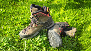
Hiking-specific technical clothing is not required, but given the length of the route and the presence of gravel sections, we recommend sporty clothing and comfortable shoes. It's also advisable to carry a backpack with at least some water, a snack, and a rain jacket. If you're new to hiking, we suggest reading our tips for enjoying an excursion safely:
We would like to highlight that there are rules to follow within the Cortina area. The main ones are:
- Lighting fires is strictly prohibited.
- Picking plants and flowers is strictly prohibited.
- Wild camping is prohibited.
- Littering is prohibited.
- Pets must be kept on a leash.
When you go on a hike, always pay attention. CiaoCortina cannot be held responsible for any changes, issues, errors, damage to property or people, or inconveniences that may occur along the route.
Have you seen our new Instagram page? Come follow us.
Conclusion
We hope you liked this page on the long walk from Cortina to San Vito. Before saying goodbye, we'd like to mention that you can discover other breathtaking hikes in Cortina and its surroundings here.
If you want to thank us, you can read the page Support Us. If you only want to suggest a change, propose something, or just say hello, in the section Contacts and Info, you'll find all the ways to reach us.