Overview
Map

Introduction
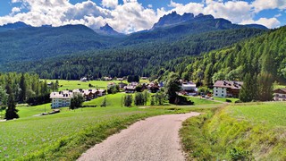
Let's discover together the loop of "Pianozes," a relaxing walk in the forest of the district of "Zuel." Halfway, we'll walk around Lake "Pianozes," a gem surrounded by greenery. From here, we'll reach the meadows of "Campo," in front of an amazing panorama of Mount "Faloria" and Mount "Antelao."

This hike can be found on Tabacco Map 003, "Cortina d'Ampezzo e Dolomiti Ampezzane," and goes along Path 449. Alternatively, you can see our route on Google Maps by clicking here.
It is a walk suitable for everyone, but you should have a minimum of training, because the length is around six kilometers, almost four miles.
 Help us stay ad-free with a small offer.Donate now!
Path of the walk
This is a loop walk, so you can start at any point of the track. We chose to start from the football field of "Zuel," which is located in the landing area of the Olympic Ski Jumping Trampoline. If you are unsure of how to reach it, we will describe it in depth down on the page in the chapter "How to Get There." Alternatively, clicking on the name will open the location on Google Maps.

From the football field, take the road downhill, towards "Pian da Lago," which is the industrial area of the town, rich in services. Most of Cortina's artisan workshops are here.

Once you've passed the barrier that blocks the passage of cars, keep right and take the gravel road, which runs alongside the buildings, for about five hundred meters.

When you reach the crossroad, near the last industrial building, turn right, towards "Socol." Here you will see the temporary village for workers to build the 2026 Olympics bobsled track. The area will later be converted to housing.

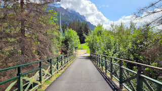
Continue along the gravel road. When you reach the lumberyard, turn left, then right, and head towards the bridge over "Boite" river. It might seem complicated, but it's the only reasonable path to take, it's nearly impossible to go the wrong way.

For now the walk has not been very naturalistic nor scenic, but after crossing the bridge the atmosphere will change completely.

After crossing the river, keep right, following the wooden sign that indicates Path 449, towards "Lago de Pianozes," which means "Pianozes" Lake. If you can read Italian, it might seem like a typo, but it's written correctly in the Ampezzo dialect.

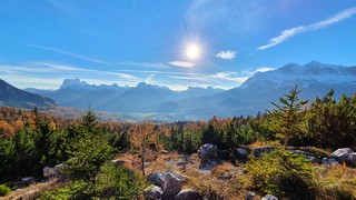
Now you have to face a short climb, which ends at a scenic point from which it is possible to see Mount "Tofane" and the "Boite" river.

Continue straight along the main road for about twenty minutes, avoiding the smaller paths into the woods that deviate from the most-walked path.

After a simple climb, and an easy descent, you will cross a wooden bridge. Immediately after you will see some benches with a strange wooden column that contains some books.
This relaxation area has been installed by the "Regole d'Ampezzo" and consists of a picnic area with a library. It is called "Librasción," here you may read a book immersed in nature, or take one, following the philosophy of book-crossing.

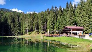
Keep walking some minutes more, initially along a gentle climb, then on flat, until you reach the suggestive Lake "Pianozes," and the restaurant of the same name. Here, you can stop to eat something or relax on the banks of the lake.
The restaurant is quite prestigious, and the prices are not exactly popular, but you can also have an ice cream, drink something, or eat a sandwich at the "Bar del bon azèto." which is a kiosk open during the summer and located on the opposite side of the lake.

Once here, we recommend turning left, taking a walk all around the lake, but you can also continue straight towards the restaurant. Once you've passed it, proceed a hundred meters along the gravel road, until you reach the asphalt road. From here, descend in the direction of the district called "Campo di Sotto."

Once you reach the end of the descent, turn right. When you reach the intersection with the electric tower, turn again to the right, along the asphalt road in the direction of "Zuel." You will enjoy a beautiful panorama of Mount "Faloria" and the vast meadows of "Campo."

Once you cross the bridge over the "Boite" river, you will have to continue along the paved road and face the last climb, before reaching the district of "Zuel."

Once at the top of the climb, you may want to take a close look at the feet of the Olympic Ski Jumping Trampoline, vestiges of the 1956 Cortina Olympics. To reach it, turn right and continue along the uphill road, the one that enters the woods.

The duration of this detour should be twenty minutes, adding the time to look at the trampoline and the beautiful panorama on the side of the jump. Currently the area is a bit neglected, but renovations are planned.

To return to the soccer field, starting point of the Loop of "Pianozes,", you must turn right just before the first houses of "Zuel, following the bike/pedestrian path in the direction of Calalzo.

After about two hundred meters you'll cross a road, turn right and walk downhill. If you fear to take the wrong road don't worry, all the roads that go downhill lead to the football field, there are at least four different ways to get there.

Using the trampoline as a reference it is practically impossible to choose the wrong way, the football field you are aiming for, in fact, is right below, as it is built on what was the landing of those who made the jump.
Help us stay ad-free with a small offer.Donate now!
Curiosities
This walk follows the track of a historical running race called "El Siro de Pianozes," that takes place for more than forty years and will allow you to get to know some of Cortina's most strategic places: the lake, the librascion relaxation area, and Pian da Lago.
Lake "Pianozes," has been created artificially, for tourism purposes. In 2019 the "Regole" of Ampezzo, the owner of the area, improved the access road and expanded the restaurant. The shores of the lake have been made accessible to people with disabilities and the peninsula where the kiosk is located has been enlarged.
The "Librasción" is a project born from the collaboration between the students of the Artistic High School of Cortina, the "Regole d'Ampezzo" and the "Ulda," the Union of the Ampezzo Ladins. It's a free "bookstore" in the woods, where you can read a book immersed in nature. The concept is the same as book-crossing, where you can take a book for free, or you can add one to the collection. The name of the project derives from the words "Libro," "book" in Italian and "Brasción," "tree" in the local dialect.
Cortina was also very important during the fascist period. The Italian monarchs, as well as Mussolini's daughter, Edda, came here as guests. In the locality of "Campo," in 1934, a summer camp for the sons of soldiers that were fighting abroad was built. Here is a video of "Campo Mussolini" on YouTube.
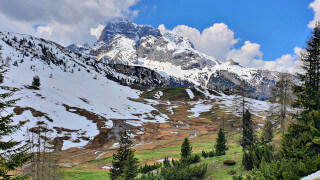
If you want to make your walk longer and more demanding, once you arrive at Lake "Pianozes," you may also go to see Lake Ajal. We describe this hike, which will take you about two hours, on the page below:
 Help us stay ad-free with a small offer.Donate now!
How to get there
"Zuel," the starting point of our walk, can be reached in different ways. If you want to take the car, you should park near the "Zuel" football field. This is a free car park that usually has available space, even in peak season, as it's not close to any point of tourist interest. The ride time, from the center of Cortina, is approximately ten minutes.
If you want to take the bus, you can take the urban line Bus No. 2 at Roma Square and get off at the bus stop at "Zuel," from here go down towards the center of "Zuel," heading towards the Ski Jumping Trampoline. We have described the piece of road that goes down towards the football field in the final part of the path of the walk.
You can find more information about buses at the ticket office at the bus station, considering that it might be closed during lunch hours.
From the center of Cortina, you can also walk in order to reach the loop of "Pianozes." You have to take the gravel road known as "Ex Polveriera" to reach "Campo di Sotto," from there you can walk towards "Zuel."
The walk will take you, in total, around three hours, with a length of around twelve kilometers, a little more than seven miles. If you want a deep description, you can read our page on the walk that, from the center of Cortina, leads to Lake "Pianozes." You can find it below:
Finally, you could consider taking a taxi to "Zuel." The cost should be, approximately, €15 but consider that prices could vary greatly, both for the type of vehicle and the number of people, so you should always ask for a quote. Taxis can be found both in Roma Square and the bus station, or you can visit the official taxi website.
For any doubts you may have, you can consult the Tourist Information office in the center of Cortina.
Help us stay ad-free with a small offer.Donate now!
Useful information
The loop of "Pianozes" can be done at any time of the year, even in winter, but the road is not regularly groomed by snowcat nor snowmobile. In case of snow it is highly recommended to have crampons to attach to your shoes, to avoid slipping on the ice. You should also have experience of walking on the snow.
During the spring the thaw could make the ground a little muddy, and in some places you may find ice. In this case, it is better to be careful not to slip. Unfortunately every season is different and it's impossible to know in advance when the snow will come or melt.
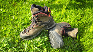
Even if this is not a difficult walk, when you go hiking, you should always use comfortable shoes and bring a backpack with some water, a snack and a rain jacket. If you are not used to mountain hikes, before venturing, we recommend you read the page below:
We want to emphasize that, in the Dolomites, there are rules to be followed. The main ones are:
- It is strictly forbidden to light fires.
- It is strictly forbidden to pick plants and flowers.
- Free camping is prohibited.
- It is prohibited to abandon garbage.
- It is mandatory to keep pets on a leash.
Always be responsible and, when in doubt, stop. CiaoCortina cannot be considered responsible for any damage to things or people, variations, wrong path,, errors or inconveniences that may occur along the route. For more information, click here.
Help us stay ad-free with a small offer.Donate now!
Conclusion
We hope you liked this page on the walk of the loop of "Pianozes." Before saying goodbye, we would like to mention that you can find other amazing hikes in Cortina and its surroundings by clicking here.
If you want to thank us you can read the page Support us. If you only want to suggest a change, propose something or just say hello, in the section contacts and info you'll find all the ways to reach us.