Overview
Map

Introduction
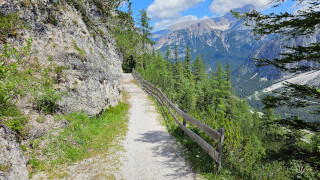
Let’s discover together the splendid "Montanelli Walk," so dear to the famous Italian journalist that has been named after him. From there, we'll reach the scenic point known as "Crepe de Cianderòu" to enjoy an amazing view of Cortina. This is a short and suggestive walk, suitable for everyone.

This hike can be found on Tabacco Map 003, "Cortina d'Ampezzo e Dolomiti Ampezzane," and goes along Paths 410 and Path 409. Alternatively, you can see our route on Google Maps by clicking here.
This is a very simple and pleasant walk, which can also be done by children and the elderly. It does not have major differences in height, and although it must be said that the last climb is a little more challenging, it is absolutely optional.

Path of the hike
This amazing walk towards the "Crepe de Cianderòu" starts in the parking area in front of the "Piè Tofana" Restaurant. It is a big and free car park, if you are unsure of how to reach it, we will describe it in depth down on the page in the chapter "How to Get There." Alternatively, clicking on the name will open the location on Google Maps.
When you surpass the restaurant you will see a wooden sign with some destinations, we will follow Path 409 towards "Cianderòu" and "Passo Posporcora."

The first part of the walk is along the same dirt road that leads to "Col Drusciè," which is open to traffic, you should stay on the edge of the road.

Once you have walked for a few hundred meters you will see an intersection, go left, following the directions "Passeggiata Montanelli." The word "passeggiata," in Italian, means walk, or stroll.

After a few meters inside the woods, on your left, a small lake will appear. It is perfectly regular, with a nice "heart" shape, this artificial lake is called "Po' Drusciè" and is used to provide water for the artificial snow on the ski slopes.

Although, on the hottest days, the temptation to take a dip is strong, keep in mind that the water is very cold and, above all, swimming is prohibited.
After visiting this peculiar lake, you shall return to the main path and continue into the woods for another 15 minutes.

You will reach a crossing called "Ra Forzèla," that is clearly identifiable by a bench and the vertical sign boards. Continue straight along the main road, from here Path 410 changes name and becomes Path 409 as you move towards "Cianderòu."

From here the panorama begins to open up, offering splendid views of the Ampezzo valley. The "Montanelli Walk" continues flat, until you reach a bench overlooking a beautiful panorama. You might think that it is the well known "Panchina Montanelli," where the writer loved to stop, but this is not the case, in fact, another half hour's walk awaits you. The word "Panchina" means bench in Italian.

Once you reach the wooden sign board of the Natural Park of the Ampezzo Dolomites continue along Path 409, in the direction of "Tonde de Cianderòu." Take the road to the left of the intersection, from here the slope changes, becoming a not too demanding climb.

After about 20 minutes of constant uphill walking, you will reach the scenic point of the "Crepe de Cianderòu." The "Montanelli Bench" overlooks this suggestive panorama, where the famous Italian writer found inspiration, observing the immortal peaks of the Dolomites.

From this observation point you can see Cortina, Mount "Faloria," Mount "Antelao," the hill of "Col Drusciè" and, in the distance, the town of "San Vito di Cadore," about thirteen kilometers, eight miles, away.
This hike offers its best in autumn, when the trees turn orange, preparing for winter, but the "Montanelli Walk" is also very beautiful both in spring and summer. The photographs on this page were taken at the beginning of November, when the colors were amazing.

This is the end of our hike. To return to the "Piè Tofana" parking lot, the starting point, just walk back the same route you took to get there.
If you think the "Montanelli Walk" has been too short, there are two scenic roads you can take to lengthen the way back.
The first detour you may take is the path that leads you to Lake "Ghedina," a small and very suggestive mountain lake, where you can also find a restaurant of the same name.
At the end of the descent from "Cianderòu," you will see again the intersection with the sign board of the "Dolomiti d'Ampezzo" Natural Park. Here, take the left, along Path 410. The duration of the detour, there and back, is approximately fifty minutes.
The second option is to visit "Col Drusciè," the hill that you could have observed from the viewpoint of "Cianderòu."
Here are located the astronomical observatory, the middle station of the cableway to Mount Tofane, and the Wine Bar "Masi," a fine winery that wonderfully represents our region's wines.
To reach "Col Drusciè" you will have to reach almost the beginning of the walk, near the "Piè Tofana" car park. From here continue along the road indicated by the Col Drusciè - Path 411 sign.
After about 15 minutes of walking uphill along you will reach "Col Drusciè," where you can enjoy a beautiful panorama of Cortina, as well as drink or eat something. Consider that the bar is open only in peak season. The duration of the detour, there and back, is approximately thirty minutes.
If you think you've already walked enough, you could also stop to eat at "Piè Tofana," where there's a restaurant of the same name. It is known for its high-level cuisine, almost of starred quality. More information can be found on the website of "Baita Piè Tofana." You should know that the standard of the restaurant is very high.
Curiosities
Path 410 is also known as "Indro Montanelli Walk," in honor of the famous Italian journalist of the same name, who loved walking along this route during his summer holidays in Cortina. He was well known and respected in Italy.
Montanelli is not the only famous writer to have fallen in love with Cortina, even Ernest Hemingway was struck by it, returning several times. He slept at the Hotel de la Poste, and always took room 107 which, in his honor, is kept unchanged.
If you have decided to visit "Col Drusciè," you may have seen the Astronomical Observatory named after "Helmut Ullrich." The structure is managed by amateur astronomers, and it boasts the discovery of 40 supernovae and a small planet, which has been called "Cortina d'Ampezzo."
The artificial lake "Po' Drusciè," with its depth of ten meters, thirty feet, and a volume of water of ninety-six thousand cubic meters, is the largest artificial lake in Ampezzo. It is used as a water reserve for making artificial snow on the ski slopes during the winter season.
There's also a more demanding hike that allows you to reach "Cianderòu" starting from "Fiames," continuing beyond the scenic point up to "Posporcora." In this case, however, the hike becomes almost twelve kilometers, seven miles and a half, and is quite exhausting. If you want to know more, you can read the page below:
How to get there
The only way to get to "Piè Tofana" is to take the car, as the locality is not reached by buses. Once you reach the destination, you can park in the large free lot. It's usually not overly crowded, except during peak season, when it's advisable to arrive early in the morning. From the center of Cortina the car park is approximately fifteen minutes by car.
If you don't have a car the only other way to reach "Piè Tofana" is to take a taxi. The price should be around 30€, but it could vary a lot, both for the type of vehicle and the number of people, you should always ask for a quote. Taxis can be found both in Roma Square and at the bus station, or you can visit the Taxi official website.
If you need any information there is a tourist information office. It is located in the town center, near the church.
Useful information
The "Montanelli Walk" can't be done in winter because it cuts through ski slopes that are prohibited for pedestrians. Usually, the most suitable months for this hike are those that go between May and November. This is a slightly conservative estimate, but unfortunately every season is different. It is not possible to know exactly when it will snow nor when the snow will melt.
If you plan to eat at one of the restaurants described above, they are usually open for most of the year. If you don't want to have bad surprises, in low season, it is always better to call to check the actual opening.
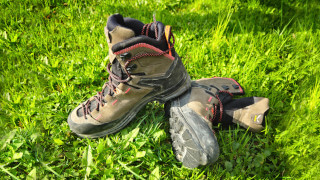
Even though this is a pretty easy walk, we suggest choosing appropriate clothing, starting with your shoes, which should be sturdy. Always carry a backpack with, at least, some water, a snack and a rain jacket. If you are new to hiking, we recommend you read the page we wrote on how to tackle a mountain outing:
We want to emphasize that, in the Dolomites, there are rules to be followed. The main ones are:
- It is strictly forbidden to light fires.
- It is strictly forbidden to pick plants and flowers.
- Free camping is prohibited.
- It is prohibited to abandon garbage.
- It is mandatory to keep pets on a leash.
Conclusion
We hope you liked this page on the "Montanelli Walk," from "Piè Tofana" to "Cianderòu." Before saying goodbye, we would like to mention that you can find other amazing hikes in Cortina and its surroundings by clicking here.
If you want to thank us you can read the page Support us. If you only want to suggest a change, propose something or just say hello, in the section contacts and info you'll find all the ways to reach us.