Overview
Map

Introduction
The hike to the mountain saddle called "Forcella Posporcora" from Fiames, passing through the "Crepe de Cianderòu," is a really scenic walk in the territories of Cortina d'Ampezzo.

You can find this hike to "Forcella Posporcora" on the Tabacco Map 003 - "Cortina d'Ampezzo Dolomiti Ampezzane," along Paths 409 and 408. Alternatively, you can see our route on Google Maps by clicking here.
This hike is very scenic, but we suggest you be fairly trained due to the length of the walk and the height differences, which are mainly concentrated in a rather steep climb and a descent with an even greater degree.
 Help us stay ad-free with a small offer.Donate now!
Path of the Hike
Our hike starts at the free parking lot near Camping Olympia. If you are unsure of how to reach it, we will describe it in depth down on the page in the chapter "How to Get There."

Start by walking up the road towards Lake Ghedina. It is a rather steep asphalt road, closed to vehicular traffic, as you can see in the picture below.

After about thirty minutes of walking uphill, you will come to an intersection delimited by two metal gates and a wooden sign indicating "Paruéto 1445 m" From here, you may take the asphalt road to the left, which is not signposted, to reach Lake Ghedina.

Lake Ghedina is a small and very suggestive mountain, here is also located an exclusive restaurant of the same name. Both can be reached with a ten-minutes walk.

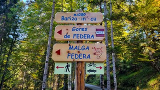
If you are not interested, continue along Path 409 towards "Cianderòu."

After about forty-five minutes of walking uphill with a constant gradient on a dirt road, you will reach the intersection called "Sote i Crepe de Cianderòu." Take the road to the right towards the "Tonde de Cianderòu."

Just a little more effort, about fifteen minutes, and you will see the scenic point of the "Crepe de Cianderòu." From here, you can breathe a sigh of relief; the climb is over, and the hike will become much more relaxing, except for the final descent.

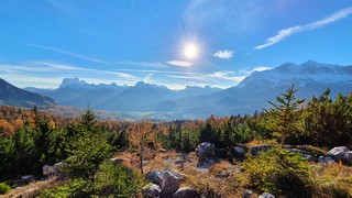
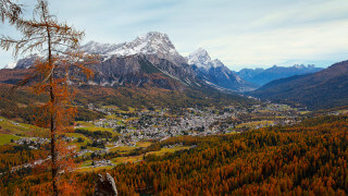
Here you will find a bench where you can relax in front of a truly suggestive view. From here, you can see Cortina, Mount "Antelao," Mount "Faloria," Mount "Col Drusciè," and, far on your right, the town of "San Vito di Cadore."
From here, the hike continues, with no particular difference in altitude, along Path 409. A sign reminds cyclists to maintain a moderate speed and to pay attention to hikers walking along the route. From here, if you encounter any side trails, always follow the signposts for "Forcella Posporcora."

In about thirty minutes, you will reach a signpost indicating the scenic point of the "Valon de ra Foia." This short deviation will let you admire the most amazing panorama of the entire hike, but you may want to avoid it if you are very afraid of heights.

Along the way. you will have the opportunity to see some very scenic views of the northern area of Cortina, including the heliport of Fiames and Mount "Col Rosà," the pyramid-shaped mountain that stands more and more majestically before you.

Just before entering the forest, you'll come across a small and rustic fountain. Here you can drink crystal-clear water that flows directly from the source, under the mountain.

Once you reach the wooden sign "Forc. Posporcora q. 1720," take Path 408 towards "Pian de Ra Spines, Fiames."

Now you will have to face a steep descent that, in two kilometers, or one mile, goes down by four hundred meters, or thirteen hundred feet, in height. Take your time and don't rush; steep mountain descents are a real challenge for your knees.

Once you reach the end of the descent, you will come across the wooden sign "Pian de Ra Spines, q. 1301." Proceed along Path 417, keeping right, towards "Camping Olympia, Cadin."

This last piece of road consists of two very relaxing and flat kilometers, almost one mile and a half, where it's also possible to see some artistic installations made by the students of the Art Institute of Cortina d'Ampezzo. These pieces of art are positioned in the woods with descriptive tables, but we'll talk about them more in depth a little down below, in the "Curiosities" section.

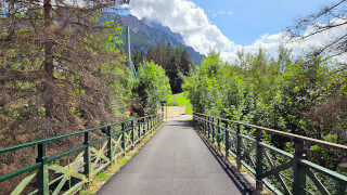
The hike ends where it started, in the parking lot of Camping Olympia. If you want to stay longer in the locality of Fiames, you could eat or drink something at the dell'Hotel Fiames, where you can relax on the terrace or at the bar. The restaurant is not far from the car park: cross the bridge over the "Boite" Stream, turn left, and follow the path, which runs alongside the state road, for about 800 meters, or 2,600 feet.
Help us stay ad-free with a small offer.Donate now!
Curiosities
The artistic installations in the woods, of which we talked previously, are part of the Paths of Art 2020 project, sponsored by the Municipality of Cortina d'Ampezzo and organized by the "Controcorrente" association and the "Regole d'Ampezzo," with the support of Quiqueg creative agency from Milan. For those who would like more information, it is possible to read the art paths project page on the official website of the association, but it's only in Italian.
If you look at the forest immediately above Cianderòu, you can clearly observe the damage done by the "Vaia" storm. In October 2018, it caused the uprooting of many trees throughout the north-east of Italy, including Cortina. The estimated cost of the damage from the storm in Veneto alone, the most affected region, was estimated at almost two billion euros, and the cleaning of the forest will continue for many more years.
If you wish to visit the panorama of the "Crepe de Cianderòu," but you prefer to do a less demanding hike, you can take the "Montanelli" Path to reach "Cianderòu" from "Piè Tofana." We talked about it on the page linked below:
Some people prefer to do the hike in reverse, climbing up from "Forcella Posporcora" and then descending from "Cianderou" towards Fiames. This could be a good solution to strain the knees a little less, but we preferred this direction as it makes the initial part less tiring.
Help us stay ad-free with a small offer.Donate now!
How to Get There
This walk to "Posporcora" starts in the locality of "Fiames." It can easily be reached both by car and by bus.
If you have a car, the best place to park is this free parking lot, near Olympia Camping. It is rather small and well known, so if you can't find free parking, you can proceed along the road and park in one of the many free parking lots nearby the former airfield, from which you will easily reach the starting point. Fiames is about a 15-minute drive from the center.
Another solution might be to take bus n°1 from Cortina's bus station and get off at the stop at Camping Olympia. For more information and to purchase tickets, you should contact the ticket office, which is located in the same office as the Tourist Information Center. It may be closed during lunch.
This walk is already quite challenging, but you may still decide to walk from the town center to the starting point of the hike. In this case, you'll need to walk two hours more along the walk known as the former railway. In Italian we call it "Ex Ferrovia."
We have described this pleasant walk in a specific page, which you can visit by clicking below:
Finally, you could take a taxi. From Cortina to Camping Olympia, the cost should be approximately €25. Considering that prices could vary a lot, both for the type of vehicle and the number of people, you should always ask for a quote. Taxis can be found both in Roma Square and at the bus station, or you can visit the taxi official website.
If you need any information, there is a tourist information office. It is located in the town center, near the church.
Help us stay ad-free with a small offer.Donate now!
Useful information
The walk from "Fiames" to "Posporcora" is not ideal in winter because the snow is not packed. Usually, the most suitable months for this hike are those that fall between June and October. This is a slightly conservative estimate, as every season is different. It is not possible to know exactly when it will snow or when the snow will melt.
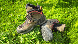
This is a challenging hike; we suggest choosing appropriate clothing, starting with your shoes, which should be sturdy. Always carry a backpack with at least some water, a snack, and a rain jacket. If you are new to hiking, we recommend you read the page we wrote on how to tackle a mountain outing:
We want to emphasize that, in the territory of the Dolomites, there are rules to be followed. The main ones are:
- It is strictly forbidden to light fires.
- It is strictly forbidden to pick plants and flowers.
- Free camping is prohibited.
- It is prohibited to abandon garbage.
- It is mandatory to keep pets on a leash.
Always be responsible, and when in doubt, stop. CiaoCortina cannot be held responsible for any damage to things or people, variations, wrong paths, errors, or inconveniences that may occur along the route. For more information, click here.
Help us stay ad-free with a small offer.Donate now!
Conclusion
We hope you liked this page about the hike from "Fiames" to "Posporcora." Before saying goodbye, we would like to mention that you can find other amazing hikes in Cortina and its surroundings by clicking here.
If you want to thank us, you can read the page Support Us. If you only want to suggest a change, propose something, or just say hello, in the section Contacts and Info, you'll find all the ways to reach us.